Lemh 60521z
This document was ed by and they confirmed that they have the permission to share it. If you are author or own the copyright of this book, please report to us by using this report form. Report 2z6p3t
Overview 5o1f4z
& View Lemh as PDF for free.
More details 6z3438
- Words: 10,486
- Pages: 34
Airport Information For LEMH Printed on 09 Jul 2016 Page 1 (c) JEPPESEN SANDERSON, INC., 2016, ALL RIGHTS RESERVED
Menorca Tower: 25.780 Military General Information Menorca Approach: 119.650 Location: MENORCA ESP ICAO/IATA: LEMH / MAH Lat/Long: N39° 51.75', E004° 13.12' Elevation: 302 ft Airport Use: Public Daylight Savings: Observed UTC Conversion: -1:00 = UTC Magnetic Variation: 1.0° E Fuel Types: 100 Octane (LL), Jet A-1 Customs: Yes Airport Type: IFR Landing Fee: Yes Control Tower: Yes Jet Start Unit: No LLWS Alert: No Beacon: No Traffic Pattern Altitude: 1302 ft (1000 ft AGL) Sunrise: 0423 Z Sunset: 1913 Z
Runway Information Runway: 01 Length x Width: 8366 ft x 148 ft Surface Type: asphalt TDZ-Elev: 284 ft Lighting: Edge, ALS, Centerline, REIL Runway: 19 Length x Width: 8366 ft x 148 ft Surface Type: asphalt TDZ-Elev: 297 ft Lighting: Edge, ALS, Centerline, REIL Displaced Threshold: 656 ft
Communication Information ATIS: 129.150 Menorca Tower: 121.750 Menorca Tower: 118.200
jep=JEPPESEN
JeppView for Windows
Airport Information For LEMH Printed on 09 Jul 2016 Page 2 (c) JEPPESEN SANDERSON, INC., 2016, ALL RIGHTS RESERVED
Menorca Tower: 25.780 Military General Information Menorca Approach: 119.650 Location: MENORCA ESP ICAO/IATA: LEMH / MAH Lat/Long: N39° 51.75', E004° 13.12' Elevation: 302 ft Airport Use: Public Daylight Savings: Observed UTC Conversion: -1:00 = UTC Magnetic Variation: 1.0° E Fuel Types: 100 Octane (LL), Jet A-1 Customs: Yes Airport Type: IFR Landing Fee: Yes Control Tower: Yes Jet Start Unit: No LLWS Alert: No Beacon: No Traffic Pattern Altitude: 1302 ft (1000 ft AGL) Sunrise: 0423 Z Sunset: 1913 Z
Runway Information Runway: 01 Length x Width: 8366 ft x 148 ft Surface Type: asphalt TDZ-Elev: 284 ft Lighting: Edge, ALS, Centerline, REIL Runway: 19 Length x Width: 8366 ft x 148 ft Surface Type: asphalt TDZ-Elev: 297 ft Lighting: Edge, ALS, Centerline, REIL Displaced Threshold: 656 ft
Communication Information ATIS: 129.150 Menorca Tower: 121.750 Menorca Tower: 118.200
jep=JEPPESEN
JeppView for Windows
Printed from JeppView for Windows 5.3.0.0 on 09 Jul 2016; Terminal chart data cycle 10-2016 (Expired); Notice: After 19 May 2016, 0000Z, this chart may no longer be valid
+ JEPPESEN
LEMH/MAH
15 APR 16
MENORCA
10-1P
.Eff.28.Apr.
MENORCA, SPAIN .AIRPORT.BRIEFING.
1. GENERAL 1.1.
ATIS *D-ATIS
1.2.
129.150
NOISE ABATEMENT PROCEDURES
1.2.1. GENERAL The following procedures are applicable to all ACFT for landing and take-off, except for safety reasons, to avoid excessive noise in areas surrounding the APT.
1.2.2. REVERSE THRUST Reverse thrust other than idle is not allowed, except for safety reasons.
1.2.3
RUN-UP TESTS Prior clearance run-up tests will be authorized between 0700-2300LT. Engine performance testing higher than idle will be allowed on THR following the TWR instructions.
1.3.
LOW VISIBILITY PROCEDURES (LVP)
1.3.1. GENERAL LVP shall be applied when Runway Visual Range (RVR) is below 600m, or in the event of transmissometer failure, the general visibility in the manoeuvring area is below 800m. The ground LVP shall be cancelled when the meteorological minima, as defined in the preceding point, are greater than 800m RVR or visibility of 1000m in the event that the transmissometer is unavailable. RWYs 01/19 are appropriate for low visibility take-offs under the conditions envisaged. Pilots shall be informed by ATIS that the LVP are in force.
1.3.2. GROUND MOVEMENT When the RVR is equal or less than 1000m, the stop bars protecting the access to the RWY shall be activated, in addition to the appropriate lighting. The stop bars will be used to manage the ground movements in the manoeuvring area. Pilots shall proceed to monitor the ACFT position at all times and ensure that taxiing takes place in conditions of complete safety. In the event that a departing ACFT has to return to the apron, pilot shall inform Tower and await new taxiing instructions.
Entry to RWY
Entry to RWY 01 shall only be accomplished by A1 via gate D and TWY T. Entry to RWY 19 may only be performed by NL via gate J and TWY T. Except in the case of code letter E ACFT, which will exit the apron by gate D and will be guided by a Follow-me vehicle up to the holding position T1, the only RWY 19 holding position. When the LVP are activated, ATC shall clear the movement of only one ACFT at a time in the movement area.
Arrival
ACFT that have already landed shall report "Runway vacated" when leaving RWY. At the parking apron entry, ACFT must wait for the arrival of a Follow-me car in order to be guided to the assigned stand and notify Tower "Follow-me in sight".
| JEPPESEN, 2007, 2016. ALL RIGHTS RESERVED.
Printed from JeppView for Windows 5.3.0.0 on 09 Jul 2016; Terminal chart data cycle 10-2016 (Expired); Notice: After 19 May 2016, 0000Z, this chart may no longer be valid
LEMH/MAH MENORCA
+ JEPPESEN 10-1P1
15 APR 16
.Eff.28.Apr.
MENORCA, SPAIN .AIRPORT.BRIEFING.
1. GENERAL Departure
Pilots shall be informed about the application of LVP by TWR. Pilots shall request clearance for start-up, notifying stand position. When RVR is lower than 185m and in the event that the TWY centerline lights are not operational, it shall be mandatory for ACFT to taxi guided by a Follow-me vehicle up to the holding position for RWY access. For take-offs under LVP the following holding positions must be used: -
RWY 01: A1 RWY 19: T1
1.3.3. ANOMALOUS SITUATIONS IN THE MANOEUVRING AREA Uncertainty about Position in the Manoeuvring Area
If a pilot doubts about the position of the ACFT in relation to the manoeuvring area, he must immediately stop the ACFT and report this circumstance to ATC (including the last known position). In situations where the pilot doubts about the position of the ACFT in relation to the manoeuvring area, but recognizes that the ACFT is on a RWY, the pilot shall immediately report this to ATC (including the last known position), and vacate the RWY as soon as possible, if they can find an appropriate TWY nearby, unless ATC should indicate otherwise, and then, stop the ACFT.
Loss of Visual between Mobile Elements
In the event that one ACFT loses visual with another, or with a vehicle with which it is maintaining its own separation, ATC shall be informed immediately, and the ACFT stopped. ATC shall take the measures that it shall deem fit.
Breakdown of ACFT
ACFT shall report the situation to ATC and await the arrival of assistance. Should it find itself on a RWY, if possible and unless ATC should indicate otherwise, this shall be vacated.
1.3.4. COMMUNICATION FAILURE If arriving ACFT has just landed, it shall hold on vacating the RWY and await the arrival of an assistance vehicle. If the ACFT already has ATC taxiing clearance, ACFT shall continue by the assigned route and stop at the limit of the ATC clearance, taking extreme care, where ACFT shall hold and await the arrival of an assistance vehicle. Departing ACFT shall continue by the assigned route and stop at the limit of the ATC clearance, taking extreme care, where ACFT shall hold the position and await the arrival of an assistance vehicle.
| JEPPESEN, 2007, 2016. ALL RIGHTS RESERVED.
Printed from JeppView for Windows 5.3.0.0 on 09 Jul 2016; Terminal chart data cycle 10-2016 (Expired); Notice: After 19 May 2016, 0000Z, this chart may no longer be valid
LEMH/MAH MENORCA
+ JEPPESEN 10-1P2
15 APR 16
.Eff.28.Apr.
MENORCA, SPAIN .AIRPORT.BRIEFING.
1. GENERAL 1.4.
TAXI PROCEDURES
1.4.1. GENERAL TWYs A1, C, D, E, F, T and NL restricted to MAX ACFT with code letter E. TWYs A2 and J restricted to MAX ACFT with code letter D. TWY NR restricted to MAX ACFT with code letter C. Pilots shall report the stand number when request to start-up. Collision avoidance with other ACFT or obstacles is responsibility of: - Pilots when taxiing on the apron; - The handling companies during push-back manoeuvre. Unless ATC advises otherwise: RWY 01 in use, ACFT shall enter to apron by gates E or J and shall exit by gate D. RWY 19 in use, ACFT shall enter to apron by gates D or E and shall exit by gate J. ACFT must be ready for towed push-back or taxiing within the next 5 MIN to the approved start-up time; pilots shall ATC if otherwise. Unless ATC advises otherwise, push-back manoeuvres shall be carried out nosing to the North with RWY 19 in use and to the South with RWY 01 in use. ATC clearances and instructions must be read back. Guidance by a Follow-me car shall only be provided to the GA stands and those which visual docking guidance system is U/S. Guidance service shall also be provided as well as by request of TWR as by request of the pilot, or in exceptional cases like LVP in force. TWR shall provide to the pilot of the ACFT the number of the stand.
1.4.2. CODE E ACFT OPERATIONS 1.4.2.1. GENERAL Code E ACFT shall taxi at low speed, with idle engine regime and, whenever pos sible and in case of four engine ACFT with external engines turned off. Guidance provided in apron. When Code E ACFT wingspan greater than 197.8'/60.3m use stand 23, stands 14, 16 and 21 shall be unavailable.
1.4.2.2. ARRIVAL Landing RWY 01: Exit via TWY F or NL to continue via TWY T to access apron via gate D. Landing RWY 19: Exit via TWY C or A1 to continue via TWY T to access apron via gate D.
1.4.2.3. DEPARTURE Take-off RWY 01: Push-back with nose towards South, exit via gate D to continue to taxiing via TWY T to A1, access to RWY via A1 (ATC authorization required). Take-off RWY19:
Push-back with nose towards South, exit via gate D to continue to taxiing via TWY T to T1, access to RWY via NL (ATC authorization required).
1.5.
PARKING INFORMATION
1.6.
OTHER INFORMATION
On stands 1, 3, 5, 7, 9, 11, 13, 15, 17, 19, 21 and 23 push-back required.
Helicopter operations. Birds in vicinity of APT. RWY 19 right-hand circuit.
| JEPPESEN, 2014, 2016. ALL RIGHTS RESERVED.
Printed from JeppView for Windows 5.3.0.0 on 09 Jul 2016; Terminal chart data cycle 10-2016 (Expired); Notice: After 19 May 2016, 0000Z, this chart may no longer be valid
LEMH/MAH MENORCA
+ JEPPESEN 10-1P3
15 APR 16
.Eff.28.Apr.
MENORCA, SPAIN .AIRPORT.BRIEFING.
2. ARRIVAL 2.1.
SPEED RESTRICTIONS
2.2.
NOISE ABATEMENT PROCEDURES
MAX 250 KT below FL 100.
Descent below 3000' will not be cleared before ACFT on final is on extended RWY centerline.
3. DEPARTURE 3.1.
PUSH-BACK DIRECTIONS
Stand 1 push-back with nose to North. Stands 3, 5, 7, 9, 11, 13, 15, 17, 19, A1 thru A8 and B1 thru B7 push-back with nose to North or South. Stands 21 and 23 push-back with nose to South.
3.2.
SPEED RESTRICTIONS
3.3.
NOISE ABATEMENT PROCEDURES
MAX 250 KT until leaving FL 100.
Modifications to the SIDs will not be cleared before leaving at least 3000' on the climb.
| JEPPESEN, 2016. ALL RIGHTS RESERVED.
Printed from JeppView for Windows 5.3.0.0 on 09 Jul 2016; Terminal chart data cycle 10-2016 (Expired); Notice: After 19 May 2016, 0000Z, this chart may no longer be valid
MENORCA
Alt Set: hPa Trans level: By ATC Trans alt: 6000' 1. The published minimum altitudes integrate no correction for low temperatures. 2. This chart should only be used for cross-checking of assigned altitudes while under radar control. BARCELONA LECB FIR
302'
.Eff.30.Apr..RADAR.MINIMUM.ALTITUDES.
10-1R
17 APR 15
SARGO
MARSEILLE LFMM FIR
Apt Elev
MENORCA, SPAIN
JEPPESEN
LEMH/MAH
MEROS
40-30
RIXOT
D14
4 D1
DONAV D9.4
D9.3 1188'
30
MHN MENORCA
R-20 0
0
^ 240
20
D1
MAMEB
R-080 D10
D6
112.6 MHN VOR DME
CARME
D2 0
D3
1500
^ 150
180^
10
0
0
10
ORFEO
BALIO 210 ^
39-30
MORSS
Menorca
120 ^
TETIS
TIMOR
D2 0
270^
.5
3 R-29 D 0
ISTER
090^
0
1500
D3 0
2300
D1 0
08
R-003
300 D22 ^
R-29
030 ^
D20
^ 060
R3
R-345
40
50
1 32 R-
40-00
0^
2000 ^ 330
R-360
D30
03-30 CHANGES:
04-00 Radials revised; MAMEB wpt added; ELPEP wpt withdrawn.
04-30 | JEPPESEN, 2010, 2015. ALL RIGHTS RESERVED.
40-00
CHANGES: Airspace - OBST - Spot ELEV.
0
39-00
Formentera
VOR/DME 117.80 IBA
02-00
Km NM
10
10
20
30
20
40
30
03-00
50
60
70 40
80
50
90
100
MEDITERRANEAN SEA
NDB 401 PTC
R FI B C LE FIR A A N LO DAA E RC RS BA GIE AL
MN
39-00
40-00
(FIS)
0
0
Sector 25W MAX 2500'
LE-R115 3500' SFC
VOR/DME 112.90 CDP
CDP PTC
18
Sector Menorca MAX 1000'
or E Corrid
ATZ
10-1V
LE-D26 UNL SFC
18
IZA IBA
NDB 394 IZA
MJV
PALMA DE MALLORCA
CST NDB 351 CST
MHN
VOR/DME 112.60 MHN
NDB 344 MN
MENORCA
1186'
CTR (D) Corridor W
Menorca
rS
Sector Ibiza MAX 1000'
1597'
IBIZA
Ibiza CTR (D)
(G) Monitor118.00 ACC
(D) 118.50 IBIZA TWR
18
0
Sector Palma VOR/DME 113.30 MJV MAX 1000'
JOA
VOR/DME 117.70 JOA 9
West Zone
Sector 35W MAX 3500'
ATZ ) D R( CT
MALLORCA (Son Bonet)
Sector 35E MAX 3500' 9
XX
POLLENSA
Mallorca
4711'
9
*LE-R145 3000'/UNL
0
Sector 4 MAX 4000'
East Zone
(D) 118.20 MENORCA TWR (G) Monitor120.70 PALMA CONTROL
o rrid Co
700' SFC
Parque Natural de Sa Dragonera
ADX NDB 384 ADX
LE-P143* 3000' SFC
POS
VOR/DME 116.40 POS
(D) CTR 118.30 PALMA TWR (G) Monitor119.40 119.15 PALMA APP
Central Zone
Sector 25E MAX 2500'
MARSEILLE LFMM FIR
Altitudes in ft Distances in NM
LE-D21B FL 245 1000'
TMA (A)* Palma FL 195 MAX ALT VFR Sector
Sector 60 MAX 6000'
03-00
27
Barcelona TMA (D)
02-00
04 JUL 14
27
JEPPESEN
27
LE-R30 700' SFC
Printed from JeppView for Windows 5.3.0.0 on 09 Jul 2016; Terminal chart data cycle 10-2016 (Expired); Notice: After 19 May 2016, 0000Z, this chart may no longer be valid
PALMA
AREA
Balearic Islands, SPAIN
Refer to corresponding VACs.
| JEPPESEN, 2004, 2014. ALL RIGHTS RESERVED.
Printed from JeppView for Windows 5.3.0.0 on 09 Jul 2016; Terminal chart data cycle 10-2016 (Expired); Notice: After 19 May 2016, 0000Z, this chart may no longer be valid
AREA
PALMA
10-1VA
04 JUL 14
+ JEPPESEN
Balearic Islands, SPAIN VFR Procedures within Palma TMA Note: See also the corresponding APCH charts of Ibiza, Menorca, Palma de Mallorca and Mallorca (Son Bonet) for the according CTR entry and exit procedures. Use of Transponder The use of SSR transponder is compulsory for all ACFT operating within Palma TMA.
ACFT shall or monitor on frequencies as depicted in boxes on Palma 10-1V.
|JEPPESEN, 2002, 2014. ALL RIGHTS RESERVED.
Printed from JeppView for Windows 5.3.0.0 on 09 Jul 2016; Terminal chart data cycle 10-2016 (Expired); Notice: After 19 May 2016, 0000Z, this chart may no longer be valid
MENORCA, SPAIN
JEPPESEN
LEMH/MAH MENORCA
*D-ATIS
Apt Elev
129.150
302'
.Eff.30.Apr.
10-2
17 APR 15
Alt Set: hPa Trans level: By ATC
.STAR.
Trans alt: 6000'
MORSS TWO BRAVO (MORSS 2B) RIXOT TWO BRAVO (RIXOT 2B) SARGO TWO BRAVO (SARGO 2B) RWY 01 ARRIVALS
[MORS2B] [RIXO2B] [SARG2B]
.SPEED: MAX 250 KT BELOW FL100 RIXOT
N40 23.5 E004 40.0
D39.5
164^
At or below
R344^
D15.0 MHN N40 04.4 E004 23.6
MORSS
R03 3^
N39 57.4 E004 40.0
13. 0D 30 ME 00 A
(IAF)
D
At or below
1
FL190
rc EA D M 00 3.0 30
rc
D15.0 MHN D21.5 N39 55.7 4^ E004 31.8 6.5 25 4000 2B
112.6 MHN MHN MENORCA
N39 51.8 E004 13.0 D13.0
213 ^
2
RI 40 2.8 XO 00 T2 B
24.5 4000O 2B
SARG
FL190
D15.0 MHN N40 06.3 E004 07.9
TETIS N39 53.8 E003 56.3
D3 7.8
SARGO N40 30.0 E003 59.5
R074^
SS MOR
278^ 098^ D13.0
IMH
(IAF)
ILS DME
ORFEO N39 49.8 E004 29.6
MN
110.3 IMH
MENORCA
344 MN D 3 0 ME A 00 rc
(IF for VOR)
D10.0 MHN N39 41.9 E004 11.4
(MHN R-186)
177^
195^
D10.0 MHN D9.3 IMH Ar N39 41.9 E004 11.1 0 c
13 .0
ME 0 D 00 1 3. 3
(IF for ILS or LOC)
188^
N39 50.2 E004 12.8
(IAF)
BALIO N39 38.9 E004 10.9
(MHN R-186/D13.0)
CHANGES: Rwy designation and layout.
MHN
R186^
3000 D13.0/1 8.0
188^
BALIO
NOT TO SCALE
006^
008^
2500
188^
2500
008^
006^
2500
186^
HOLDINGS OVER MHN MN
| JEPPESEN, 2003, 2015. ALL RIGHTS RESERVED.
Printed from JeppView for Windows 5.3.0.0 on 09 Jul 2016; Terminal chart data cycle 10-2016 (Expired); Notice: After 19 May 2016, 0000Z, this chart may no longer be valid
MENORCA, SPAIN
JEPPESEN
LEMH/MAH MENORCA
*D-ATIS
Apt Elev
129.150
302'
.Eff.30.Apr.
10-2A
17 APR 15
Alt Set: hPa Trans level: By ATC
.STAR.
Trans alt: 6000'
MORSS THREE FOXTROT (MORSS 3F) [MORS3F] RIXOT THREE FOXTROT (RIXOT 3F) [RIXO3F] SARGO THREE FOXTROT (SARGO 3F) [SARG3F] RWY 19 ARRIVALS .SPEED: MAX 250 KT BELOW FL100
SARGO N40 30.0 E003 59.5
RIXOT
164^
N40 23.5 E004 40.0
D39.5
At or below
2
D3 13^ 7.8
FL190
RI 40 2.8 XO 00 T3 F
24.5 4000O 3F
SARG
1 2
2
For VOR approach
001^ 019^ (IAF)
(MHN R-010/ D13.0)
008^
(IF for VOR)
D10.0 MHN N40 01.6 E004 15.5
(MHN R-010)
MAO 112.6 MHN MHN
rc EA DM 0 .0 300
D10.6 MHN D10.0 MAO N40 02.3 E004 15.3
ILS DME
111.5 MAO
R074^
(IAF)
D
MORSS
N39 57.4 E004 40.0
13
(IF for ILS or LOC)
D15.0 MHN N40 04.4 E004 23.6
R03 3^
2
018^
1
R344^
13.0 DME Arc 3000
359^
D15.0 MHN N40 06.3 E004 07.9
DONAV N40 04.6 E004 16.2
At or below
FL190 D21.5 ^ 254 6.5 4000 3F
SS
MOR
D15.0 MHN N39 55.7 E004 31.8
MENORCA
(IAF)
MN
MENORCA
N39 51.8 E004 13.0
344 MN N39 50.2 E004 12.8
188^
2500
MN
008^
190^
CHANGES: Rwy designation and layout.
2500
010^
R010^
MH N
3000
190^
DONAV
HOLDINGS OVER MHN
NOT TO SCALE
| JEPPESEN, 2003, 2015. ALL RIGHTS RESERVED.
Printed from JeppView for Windows 5.3.0.0 on 09 Jul 2016; Terminal chart data cycle 10-2016 (Expired); Notice: After 19 May 2016, 0000Z, this chart may no longer be valid
MENORCA, SPAIN
JEPPESEN
LEMH/MAH MENORCA
17 APR 15
*D-ATIS
Apt Elev
129.150
302'
.Eff.30.Apr.
10-2B
Alt Set: hPa Trans level: By ATC
.RNAV.STAR.
Trans alt: 6000'
KABRE ONE BRAVO (KABRE 1B) [KABR1B] RWY 01 RNAV ARRIVAL (B-RNAV) B-RNAV APPROVAL REQUIRED FOR FLIGHTS FROM LEIB ONLY
PORTO COLOM ONE BRAVO (PTC 1B) TONIS TWO BRAVO (TONIS 2B) [TONI2B] 1 RWY 01 ARRIVALS FOR FLIGHTS FROM LEPA ONLY
.SPEED: MAX 250 KT BELOW FL100 (IAF)
D
112.6 MHN MHN MENORCA
N39 51.8 E004 13.0
^ 059
MN
MENORCA
110.3 IMH
344 MN N39 50.2 E004 12.8
R23
9^ (IF for ILS or LOC)
D10.0 MHN D9.3 IMH 13 N39 41.9 E004 11.1 .0 D 3 0 ME A 0 0 rc
(IF for VOR)
D10.0 MHN N39 41.9 E004 11.4
(MHN R-186)
195^
D15.0 MHN N39 44.3 E003 56.2
0
N39 46.5 E003 15.7
(IAF)
ILS DME
188^
TONIS
IMH
R263^ 30 0
D15.0 MHN N39 50.1 E003 53.6 083^ 24090.40 2B 1 TONIS D44.4
37 0 0 4 0 1B
C PT
(IAF)
BALIO N39 38.9 E004 10.9 (MHN R-186/D13.0)
401 PTC PTC
PORTO COLOM
65 0 B 400RE 1
N39 25.6 E003 15.4 7 2. D7
B KA
3^ 23
1 Usable only under RADAR control or by RNAV equipped aircraft.
^ 061
KABRE
CHANGES: STARs withdrawn, transferred and revised.
3000 D13.0/1 8.0
R186^
MHN
BALIO 188^
2500
008^
2500
008^
188^
2500 NOT TO SCALE
006^
186^
HOLDINGS OVER MHN MN
006^
N39 08.6 E002 57.4
| JEPPESEN, 2012, 2015. ALL RIGHTS RESERVED.
Printed from JeppView for Windows 5.3.0.0 on 09 Jul 2016; Terminal chart data cycle 10-2016 (Expired); Notice: After 19 May 2016, 0000Z, this chart may no longer be valid
MENORCA, SPAIN
JEPPESEN
LEMH/MAH MENORCA
17 APR 15
*D-ATIS
Apt Elev
129.150
302'
.Eff.30.Apr.
10-2C
Alt Set: hPa Trans level: By ATC
.STAR.
Trans alt: 6000'
KABRE ONE FOXTROT (KABRE 1F)
[KABR1F]
FOR FLIGHTS FROM LEIB ONLY
PORTO COLOM ONE FOXTROT (PTC 1F) TONIS THREE FOXTROT (TONIS 3F) [TONI3F] FOR FLIGHTS FROM LEPA ONLY
RWY 19 ARRIVALS
.SPEED: MAX 250 KT BELOW FL100 (IAF)
For VOR approach
1
DONAV N40 04.6 E004 16.2
001^
1
359^
(MHN R-010/ D13.0)
c Ar 0
(IF for ILS or LOC)
D10.6 MHN D10.0 MAO N40 02.3 E004 15.3 (IAF)
D
TONIS N39 46.5 E003 15.7
083^
112.6 MHN MHN
D10.0 MHN N40 01.6 E004 15.5
(MHN R-010)
MENORCA
N39 51.8 E004 13.0
TETIS N39 53.8 E003 56.3 D15.0 MHN N39 50.1 E003 53.6 29.4 4000
(IF for VOR)
008^
1 3. 0D 3 0 ME 0
NOT TO SCALE
D13.0
278^
MAO ILS DME
111.5 MAO
R263^
D44.4 TONIS 3F
(IAF)
MN
MENORCA
344 MN
PORTO COLOM
401 PTC
N39 25.6 E003 15.4
.7 57 0 0 F 40 E 1
BR KA
KABRE
DONAV 190^
N39 08.6 E002 57.4
HOLDINGS OVER MHN
010^
3000
MH N
R010^
CHANGES: STARs transferred and revised.
MN 188^
^ 053
2500
.7
C PT
190^
2 D7
D15.0 MHN N39 43.0 E003 57.3
2500
0
59^
37 0 0 4 0 1F
N39 50.2 E004 12.8
008^
PTC
9^ R23 33^ R2
D15.0 MHN N39 44.3 E003 56.2
| JEPPESEN, 2012, 2015. ALL RIGHTS RESERVED.
Printed from JeppView for Windows 5.3.0.0 on 09 Jul 2016; Terminal chart data cycle 10-2016 (Expired); Notice: After 19 May 2016, 0000Z, this chart may no longer be valid
MENORCA Apt Elev
302'
MENORCA, SPAIN
JEPPESEN
LEMH/MAH
17 APR 15
.Eff.30.Apr.
10-3
.SID.
Trans level: By ATC Trans alt: 6000' EXPECT close-in obstacles.
LUNIK TWO CHARLIE (LUNIK 2C) [LUNI2C] MEROS ONE CHARLIE (MEROS 1C) [MERO1C] SARGO TWO CHARLIE (SARGO 2C) [SARG2C] RWY 01 DEPARTURES MAX 250 KT UNTIL LEAVING FL100 .SPEED:
SARGO
MEROS
N40 30.0 E003 59.5
N40 30.0 E004 22.0 D38.8
D39.5
LUNIK
N40 26.4 E003 23.5 D5 1. 3
O 2C
29.8
MEROS 1
C
SARG
2C
D
112.6 MHN MHN MENORCA
^
NOT TO SCALE
2^
350'
(MHN D9.0)
2.0
328
31
344^
DME 9.0 Arc
TIMOR N40 00.7 E004 15.0
299 ^ h dg
D7.0 MHN N39 58.7 E004 14.6
010^
LU NI K
N39 51.8 E004 13.0
SID LUNIK 2C
ROUTING Climb on MHN R-010 to D7.0 MHN, turn LEFT, along MHN 9.0 DME arc, intercept MHN R-312 to LUNIK. 1 MEROS 1C 2 Climb on MHN R-010 via TIMOR to MEROS. SARGO 2C Climb on MHN R-010 to D7.0 MHN, turn LEFT, 299^ heading, intercept MHN R-344 to SARGO. 3 For flights to LEBL, LEDA & LERS only. 1 2 Mandatory for flights to LEGE. 3 For flights to French aerodromes south of N44^ parallel. CHANGES: Rwy designation and layout.
| JEPPESEN, 2012, 2015. ALL RIGHTS RESERVED.
Printed from JeppView for Windows 5.3.0.0 on 09 Jul 2016; Terminal chart data cycle 10-2016 (Expired); Notice: After 19 May 2016, 0000Z, this chart may no longer be valid
MENORCA Apt Elev
302'
MENORCA, SPAIN
JEPPESEN
LEMH/MAH
10-3A
17 APR 15
Trans level: By ATC
.SID.
.Eff.30.Apr.
Trans alt: 6000'
LUNIK TWO DELTA (LUNIK 2D) [LUNI2D] MEROS TWO DELTA (MEROS 2D) [MERO2D] SARGO TWO GOLF (SARGO 2G) [SARG2G] RWY 19 DEPARTURES MAX 250 KT UNTIL LEAVING FL100 .SPEED: MEROS
N40 30.0 E004 22.0 D38.8
D39.5
SARGO
N40 30.0 E003 59.5
LUNIK
O 2G
MEROS 2
SARG
D
N40 26.4 E003 23.5 D5 1. 3
2D
^
31 2^ 292^
344^
324
NOT TO SCALE
D
MHN MENORCA
010^ 029 ^
LU NI K
112.6 MHN 186^
N39 51.8 E004 13.0 7.0
D5.0 MHN
D
ME
Arc
ME 7.0 D
Arc
SID LUNIK 2D
ROUTING Climb on MHN R-186 to D5.0 MHN, turn RIGHT, along MHN 7.0 DME arc, intercept MHN R-312 to LUNIK. 1 MEROS 2D Climb on MHN R-186 to D5.0 MHN, turn LEFT, along MHN 7.0 DME arc, intercept MHN R-010 to MEROS. 2 SARGO 2G Climb on MHN R-186 to D5.0 MHN, turn RIGHT, along MHN 7.0 DME arc, intercept MHN R-344 to SARGO. 3 For flights to LEBL, LEDA & LERS only. 1 2 Mandatory for flights to LEGE. 3 For flights to French aerodromes south of N44^ parallel. CHANGES: Rwy designation and layout.
| JEPPESEN, 2012, 2015. ALL RIGHTS RESERVED.
Printed from JeppView for Windows 5.3.0.0 on 09 Jul 2016; Terminal chart data cycle 10-2016 (Expired); Notice: After 19 May 2016, 0000Z, this chart may no longer be valid
JEPPESEN
LEMH/MAH MENORCA Apt Elev
302'
.Eff.30.Apr.
10-3B
17 APR 15
MENORCA, SPAIN .SID.
Trans level: By ATC Trans alt: 6000' EXPECT close-in obstacles.
ISTER TWO CHARLIE (ISTER 2C) [ISTE2C] MAMEB ONE CHARLIE (MAMEB 1C) [MAME1C] MAMEB ONE HOTEL (MAMEB 1H) [MAME1H] MORSS TWO CHARLIE (MORSS 2C) [MORS2C] NEVIC ONE CHARLIE (NEVIC 1C) [NEVI1C] NEVIC ONE HOTEL (NEVIC 1H) [NEVI1H] RWY 01 DEPARTURES .SPEED: MAX 250 KT UNTIL LEAVING FL100 ISTER
N40 03.9 E004 40.0 4.0 D2
350'
MAMEB N39 45.8 E003 59.5
D
.4 48
04 3^
23 ^
9^ 255^ 2.0 23228^ 244^ 1EB 1H M MA
EA rc
010^
D7.0 MHN N39 58.7 E004 14.6
DM
R0 43 NMA ^ E M VI E B C 1 2 1H H
9.0 MAM DME NEV EB Arc IC 1C 1C
9. 0
D
^ 059 074^
R TE IS
2C
MORSS N39 57.4
E004 40.0 D21.5
C SS 2 MOR
MHN MENORCA
112.6 MHN
N39 51.8 E004 13.0 At or above
D
V NE
IC
H ,1 C 1
NEVIC
4000'
NOT TO SCALE
N39 19.9 E003 25.9
ROUTING Climb on MHN R-010 to D7.0 MHN, turn RIGHT, along MHN 9.0 DME arc, intercept MHN R-059 to ISTER. MAMEB 1C Climb on MHN R-010 to D7.0 MHN, turn LEFT, along MHN 9.0 DME arc, intercept MHN R-239 to MAMEB. 1 MAMEB 1H Climb on MHN R-010 to D7.0 MHN, turn RIGHT, along MHN 9.0 DME arc, intercept MHN R-043 inbound to MHN, MHN R-239 to MAMEB. 1 MORSS 2C Climb on MHN R-010 to D7.0 MHN, turn RIGHT, along MHN 9.0 DME arc, intercept MHN R-074 to MORSS. NEVIC 1C Climb on MHN R-010 to D7.0 MHN, turn LEFT, along MHN 9.0 DME arc, intercept MHN R-228 to NEVIC. 2 NEVIC 1H Climb on MHN R-010 to D7.0 MHN, turn RIGHT, along MHN 9.0 DME arc, intercept MHN R-043 inbound to MHN, MHN R-228 to NEVIC. 2 For flights to LEPA only. 1 2 Mandatory for flights to LEIB. SID ISTER 2C
CHANGES: Rwy designation and layout.
| JEPPESEN, 2012, 2015. ALL RIGHTS RESERVED.
Printed from JeppView for Windows 5.3.0.0 on 09 Jul 2016; Terminal chart data cycle 10-2016 (Expired); Notice: After 19 May 2016, 0000Z, this chart may no longer be valid
JEPPESEN
LEMH/MAH MENORCA Apt Elev
302'
10-3C
17 APR 15
Trans level: By ATC
.Eff.30.Apr.
MENORCA, SPAIN .SID.
Trans alt: 6000'
ISTER TWO DELTA (ISTER 2D) [ISTE2D] MAMEB ONE DELTA (MAMEB 1D) [MAME1D] MORSS TWO DELTA (MORSS 2D) [MORS2D] NEVIC ONE DELTA (NEVIC 1D) [NEVI1D] RWY 19 DEPARTURES .SPEED: MAX 250 KT UNTIL LEAVING FL100
ISTER
N40 03.9 E004 40.0 4.0 D2
D
MHN
TE IS
MENORCA
112.6 MHN
D R2
ME
C VI
4 8. D4
1D
A rc
282^hdg
^ 059 074^^ 079 094^
N39 57.4 E004 40.0 D21.5
D SS 2 MOR
DM E
Arc
D5.0 MHN
7.0
2.0
N39 45.8 E003 59.5
21 9^
MAMEB
^ 239 D1 B ME 8 ^ MA 1D 22 D 7.0 2.0
186^
N39 51.8 E004 13.0
MORSS
CARME N39 44.9 E004 11.9
(MHN D7.0)
NE
NEVIC
N39 19.9 E003 25.9 NOT TO SCALE
SID ISTER 2D
ROUTING Climb on MHN R-186 to D5.0 MHN, turn LEFT, along MHN 7.0 DME arc, intercept MHN R-059 to ISTER. MAMEB 1D Climb on MHN R-186 to D5.0 MHN, turn RIGHT, along MHN 7.0 DME arc, intercept MHN R-239 to MAMEB. 1 MORSS 2D Climb on MHN R-186 to D5.0 MHN, turn LEFT, along MHN 7.0 DME arc, intercept MHN R-074 to MORSS. NEVIC 1D Climb on MHN R-186 to CARME, turn RIGHT, 282^ heading, intercept MHN R-228 to NEVIC. 2 For flights to LEPA only. 1 2 Mandatory for flights to LEIB. CHANGES: Rwy designation and layout.
| JEPPESEN, 2012, 2015. ALL RIGHTS RESERVED.
CHANGES: MJV VORDME renamed.
32
280^
Climb on MHN R-010 to D7.0 MHN, turn RIGHT, along D9.0 MHN Arc, intercept MHN R-043 inbound to MHN, MHN R-228 to NEVIC, turn RIGHT, intercept MJV R-100 inbound to MJV.
MJV 3H
1
Climb on MHN R-010 to D7.0 MHN, turn LEFT, along D9.0 MHN Arc, intercept MHN R-228 to NEVIC, turn RIGHT, intercept MJV R-100 inbound to MJV.
Climb on MHN R-010 to D7.0 MHN, turn RIGHT, along D9.0 MHN Arc, intercept MHN R-043 inbound to MHN, MHN R-228 to NEVIC, turn RIGHT, intercept MJV R-100 inbound to MJV, MJV R-292 to ADX, turn LEFT, 274^ bearing to EPAMA.
EPAMA 1H
MJV 3C
Climb on MHN R-010 to D7.0 MHN, turn LEFT, along D9.0 MHN Arc, intercept MHN R-228 to NEVIC, turn RIGHT, intercept MJV R-100 inbound to MJV, MJV R-292 to ADX, turn LEFT, 274^ bearing to EPAMA.
Climb on MHN R-010 to D7.0 MHN, turn RIGHT, along D9.0 MHN Arc, intercept MHN R-043 inbound to MHN, MHN R-228 to NEVIC, turn RIGHT, intercept MJV R-100 inbound to MJV, MJV R-263 to EDULI.
Mandatory for flights via LFBB FIR/UIR.
1
.Eff.31.Mar.
1
MH NEVIC N39 19.9 E003 25.9
D
Climb on MHN R-010 to D7.0 MHN, turn LEFT, along D9.0 MHN Arc, intercept MHN R-228 to NEVIC, turn RIGHT, intercept MJV R-100 inbound to MJV, MJV R-263 to EDULI.
ROUTING
E DU I 1 C, 1H EPAMLA MJV 3C1C, 1H , 3H
JEPPESEN
EPAMA 1C
EDULI 1H
RWY 01
R100^
10-3D
SID EDULI 1C
292^ 263^
.4 48
E DU N E PA LI A M MA 1C J V 3C 1
244^
c Ar
EDULI 1C, 1H
D 15.9
1
EPA 8 1C, MA 1H
4000'
8^ 22
18 MAR 16
EDULI
274^
113.3 MJV MJV
N39 26.1 E002 45.5
MALLORCA
At or above
350'
MENORCA
N39 24.4 E002 25.0
279^
47
D
MHN
MENORCA
112.6 MHN
N39 51.8 E004 13.0
D
0M H
LEMH/MAH
D64.8
N39 36.2 E001 22.8
EPAMA
NOT TO SCALE
C
D7.0 MHN N39 58.7 E004 14.6
R0 43 ^ EP EDU 2 MJAM LI 1 23^ A H V 3H 1H
N
N39 33.0 E002 23.8
384 ADX ADX
ANDRAITX
rc
302'
010^
Apt Elev
D9.0
D 9.
Printed from JeppView for Windows 5.3.0.0 on 09 Jul 2016; Terminal chart data cycle 10-2016 (Expired); Notice: After 19 May 2016, 0000Z, this chart may no longer be valid
MENORCA, SPAIN .SID.
Trans level: By ATC Trans alt: 6000' EXPECT close-in obstacles.
EDULI 1C [EDUL1C] EDULI 1H [EDUL1H] EPAMA 1C [EPAM1C] EPAMA 1H [EPAM1H] MALLORCA 3C (MJV 3C) MALLORCA 3H (MJV 3H)
.SPEED: MAX 250 KT UNTIL LEAVING FL100
| JEPPESEN, 2012, 2016. ALL RIGHTS RESERVED.
CHANGES: MJV VORDME renamed.
ROUTING
Mandatory for flights via LFBB FIR/UIR.
1
Climb on MHN R-186 to CARME, turn RIGHT, 282^ heading, intercept MHN R-228 to NEVIC, turn RIGHT, intercept MJV R-100 inbound to MJV.
MJV 3D
1
Climb on MHN R-186 to CARME, turn RIGHT, 282^ heading, intercept MHN R-228 to NEVIC, turn RIGHT, intercept MJV R-100 inbound to MJV, MJV R-292 to ADX, turn LEFT, 274^ bearing to EPAMA.
280^
NOT TO SCALE
NEVIC N39 19.9 E003 25.9
4 8. D4
.Eff.31.Mar.
Climb on MHN R-186 to CARME, turn RIGHT, 282^ heading, intercept MHN R-228 to NEVIC, turn RIGHT, intercept MJV R-100 inbound to MJV, MJV R-263 to EDULI.
E DU EPAMLAI 1D MJV 3D1D
32
JEPPESEN
EPAMA 1D
RWY 19
R100^
282^hdg
18 MAR 16
10-3E
SID EDULI 1D
EDULI 1D
292^ 263^
186^ CARME N39 44.9 E004 11.9
Trans level: By ATC
D 15.9
EPA 18 MA 1D
8^ 22
MENORCA
EDULI
274^
MJV
MALLORCA
113.3 MJV
N39 26.1 E002 45.5
D
LEMH/MAH
N39 24.4 E002 25.0
279^
47
N39 33.0 E002 23.8
MHN
MENORCA
112.6 MHN
N39 51.8 E004 13.0
D
302'
D64.8
N39 36.2 E001 22.8
EPAMA
384 ADX ADX
ANDRAITX
Printed from JeppView for Windows 5.3.0.0 on 09 Jul 2016; Terminal chart data cycle 10-2016 (Expired); Notice: After 19 May 2016, 0000Z, this chart may no longer be valid
MENORCA, SPAIN .SID.
Apt Elev Trans alt: 6000'
EDULI 1D [EDUL1D] EPAMA 1D [EPAM1D] MALLORCA 3D (MJV 3D)
.SPEED: MAX 250 KT UNTIL LEAVING FL100
| JEPPESEN, 2012, 2016. ALL RIGHTS RESERVED.
D7.0
Printed from JeppView for Windows 5.3.0.0 on 09 Jul 2016; Terminal chart data cycle 10-2016 (Expired); Notice: After 19 May 2016, 0000Z, this chart may no longer be valid
LEMH/MAH MENORCA
JEPPESEN 17 APR 15
10-3F
.Eff.30.Apr.
MENORCA, SPAIN .SID.
RWYS 01, 19 CONTINGENCY DEPARTURES
EXPECT RADAR VECTORING CONTINGENCY DEPARTURE BY PALMA APP TO THE ATS ROUTE. MENORCA TWR TRANSFERS THE TRAFFIC TO PALMA APP UPON DEPARTURE AND THE TRAFFIC WILL FOLLOW THE NEXT INSTRUCTIONS. RWY 01: Climb on runway heading to 3000', turn and follow the ATC instructions. RWY 19: Climb on runway heading to 2000', turn and follow the ATC instructions.
These departures require a minimum climb gradient of RWY 01: 4.2% up to 3000'. Gnd speed-KT 75 100 150 200 250 300 4.2% V/V (fpm) 319 425 638 851 1063 1276
CHANGES: Rwy designation.
| JEPPESEN, 2012, 2015. ALL RIGHTS RESERVED.
Printed from JeppView for Windows 5.3.0.0 on 09 Jul 2016; Terminal chart data cycle 10-2016 (Expired); Notice: After 19 May 2016, 0000Z, this chart may no longer be valid
LEMH/MAH 302'
MENORCA, SPAIN
JEPPESEN
Apt Elev N39 51.8 E004 13.1 *D-ATIS
.Eff.17.Sep.
10-9
4 SEP 15 ACARS: *D-ATIS
MENORCA
*MENORCA Ground
*Tower
121.750
118.2
129.150 04-13
04-12
04-14
19
188^
NR
NL
HS
Elev 302' T1
Holding position T1 on twy T: pay attention to signalization and do not cross without ATC authorization.
T J F
2550m
HS
01^E
HOT SPOTS For information only, not to be construed as ATC instructions.
39-52
39-52 E
AIS + MET
VOR LEGEND
Control Tower
ARP
No entry
D
8366'
General aviation
For AIRPORT BRIEFING refer to 10-1P pages
FOR DETAILS SEE 10-9A T
C
A1
Elev 277'
A2
39-51
39-51 Feet 0
01 008
1000
Meters 0
^
04-12
2000
4000
3000
500
5000
1000
04-13
1500
04-14
ADDITIONAL RUNWAY INFORMATION USABLE LENGTHS LANDING BEYOND Glide Slope
Threshold
RWY 01
HIRL (50m) CL (15m) HIALS REIL
19
23
RVR
HIRL (50m) CL (15m) HIALS REIL PAPI-R (3.0^)
4
7710' 2350m
1
TAKE-OFF
6604' 2013m 7710' 2350m
WIDTH
1
148' 45m
6580' 2006m
1 Last 656'/200m of rwy 01 not available for take-off and landing. 2 PAPI (angle 3.00^), not suitable for A333 ACFT. 3 HSTIL-F 4 HSTIL-C
.Standard. Approved Operators
A B C D
1
TAKE-OFF
1
LVP must be in force
HIRL, CL & mult. RVR req
RL, CL & mult. RVR req
RL & CL
RCLM (DAY only) or RL
125m
150m
200m
250m
200m
250m
300m
150m
RCLM (DAY only) or RL
NIL (DAY only)
400m
500m
Operators applying U.S. Ops Specs: CL required below 300m; approved HUD required below 150m.
CHANGES: None.
| JEPPESEN, 1999, 2015. ALL RIGHTS RESERVED.
Printed from JeppView for Windows 5.3.0.0 on 09 Jul 2016; Terminal chart data cycle 10-2016 (Expired); Notice: After 19 May 2016, 0000Z, this chart may no longer be valid
LEMH/MAH
JEPPESEN
10-9A
4 SEP 15
.Eff.17.Sep.
F 2 1
4
5
8
7
5A 7A
TERMINAL
9
E
RWY 0 1/19
CARGO
11 10
13 15
12
T
17 14
N39 N39 N39 N39 N39
52.1 52.1 52.0 52.0 52.0
E004 E004 E004 E004 E004
13.5 13.4 13.5 13.4 13.5
6 7, 7A 8 9 10
N39 N39 N39 N39 N39
52.0 52.0 52.0 51.9 51.9
E004 E004 E004 E004 E004
13.4 13.5 13.4 13.5 13.4
11 12 13 14 15
N39 N39 N39 N39 N39
51.9 51.8 51.9 51.8 51.9
E004 E004 E004 E004 E004
13.5 13.4 13.4 13.3 13.4
16 17, 19, 21 23 A1 thru A3 A4
N39 N39 N39 N39 N39
51.8 51.8 51.7 51.6 51.6
E004 E004 E004 E004 E004
13.3 13.4 13.4 13.4 13.3
A5 thru A7 A8, B1 B2 thru B7
N39 51.7 E004 13.3 N39 51.7 E004 13.4 N39 51.7 E004 13.3
AIS + MET
19
ARP 16
D
1 2 3 4 5, 5A
3
6
E
MENORCA
INS COORDINATES STAND No. COORDINATES
J
T
MENORCA, SPAIN
Control Tower
21 23
D
General aviation
T
NOT TO SCALE
B7
B6
B5 B4 B3
General aviation
B2 B1 A8
A7
A6
A5
A4
A3
A2
A1
LEGEND No entry
CHANGES: Stands.
| JEPPESEN, 2000, 2015. ALL RIGHTS RESERVED.
Printed from JeppView for Windows 5.3.0.0 on 09 Jul 2016; Terminal chart data cycle 10-2016 (Expired); Notice: After 19 May 2016, 0000Z, this chart may no longer be valid
LEMH/MAH
JEPPESEN 1 MAR 13
10-9B
.Eff.7.Mar.
MENORCA, SPAIN MENORCA
VISUAL DOCKING GUIDANCE SYSTEM GENERAL
This system contains information about azimuth guidance (shows the aircraft position with relation to the centerline of the parking area) and distance to the stop position, (based on a laser radar measurement), that is provided by a display unit, in front of the cockpit.
DISPLAY UNIT
Consists of: 1. One alphanumeric presentation line of 4 characters, composed by yellow LED, which can indicate several information: 'ACFT TYPE, STOP, OK, TOO FAR, SLW, WAIT TEST, ID FAIL and DOWN GRADE'. 2. One line with a unit of yellow LED and 2 units of red/yellow LED for indication of acft azimuth and stop indication. 3. One column of 3 units of yellow LED in the center to indicate the distance to the stop position.
PILOT INSTRUCTIONS
GENERAL ADVICE When the pilot is not sure about the information shown in the display unit, he must immediately stop the acft and obtain more information to proceed. 1. DOCKING START When the system starts, it shows the flashing message: 'WAIT TEST'. 2. CAPTURE When the system is working in capture way, looking for the approaching acft, the system shows vertical floating arrows. The first line of the display unit will show the 'ACFT TYPE'. ADVICE: If the system does not show vertical arrows in movement and an acft type like the approaching acft, the pilot must not enter into the stand point area. 3. MONITORING When the acft has been captured by the laser, the floating arrows are substituted by the yellow indicator in the centerline. A flashing red arrow shows the pilot the direction of turn in order to line-up along the stand edge. If the system does not show the direction arrows, it means the acft is over the centerline. 4. APPROACH RATE When the acft is less than 52'/16m from the stop point, the approach rate is shown by one LED line turn-off from the centerline each 2'/0,7m covered when the acft moves until the stop position. 5. SPEED REDUCTION When the acft exceeds 3.5 m/sec, the display unit indicates 'SLOW', the approach speed must be reduced. 6. REACHING STOP POINT When the correct stop point is reached, the display unit shows 'STOP' and red bar lights turn on. 7. DOCKING FINISHED When the acft is parked, the display unit shows 'OK'. 8. EXCEEDED When the acft exceeds the stop point, the display unit shows 'TOO FAR'. 9. WAIT When the detected acft is lost during the docking routine, 39'/12m before the stop point, the display unit will show 'WAIT'. The routine will continue when the system detects the acft again. 10. ADVERSE METEOROLOGICAL CONDITIONS When the system visibility is reduced due to any reason, the display unit will show 'DOWN GRADE'. As soon as the system identifies the acft, the display unit will show the rate approach bar in order to continue the docking routine. ADVICE: The pilot must not exceed the boarding bridge unless the message 'DOWN GRADE' had been substituted by the rate approach bar.
CHANGES: New page.
| JEPPESEN, 2013. ALL RIGHTS RESERVED.
Printed from JeppView for Windows 5.3.0.0 on 09 Jul 2016; Terminal chart data cycle 10-2016 (Expired); Notice: After 19 May 2016, 0000Z, this chart may no longer be valid 17 APR 15
.Eff.30.Apr.
TM
MENORCA
BRIEFING STRIP
MENORCA, SPAIN ILS Z or LOC Z Rwy 01
JEPPESEN
LEMH/MAH
11-1
*D-ATIS
*MENORCA Approach
*MENORCA Tower
*Ground
129.150
119.650
118.2
121.750
LOC IMH
Final Apch Crs
110.3
008^
ILS DA(H) Refer to Minimums
GS
D3.0 IMH
1292'
(1015')
Apt Elev 302'
2500'
Rwy 277'
MISSED APCH: Climb on rwy heading to 2000', then turn RIGHT direct to VOR climbing to 2500' and hold.
MSA MHN VOR Trans alt: 6000'
Trans level: By ATC Alt Set: hPa Rwy Elev: 10 hPa 1. ILS DME reads zero at rwy 01 threshold. 2. Racetracks restricted to MAX 220 KT.
DME required. ADF required.
ILS: No obstacle free zone rwy 01.
MHN
008^
MENORCA
112.6 MHN 188^
(IAF)
D1.0 IMH D1.7 MHN
MN
MENORCA
344 MN
39-50
188^
10
D
5
509'
(IAF)
39-55
MHA 2500
D3.0 IMH D3.7 MHN
MHA 2500
D4.0 IMH D4.7 MHN
0
39-45
IMH ILS DME
008^
008^ 110.3 IMH 04-00
04-10
5
LOC (GS out)
04-20 3.0 1330'
IMH DME ALTITUDE
NDB
1600'
008^
VOR 188^ 2500'
2500'
188^ CAT A & B: 3 Min CAT C & D: 2 Min
2.0 1000'
D1.0
D3.0IMH
IMH D1.7 MHN
D3.7 MHN
TCH 52'
D4.0 IMH D4.7 MHN
GS 1292'
1.0 Gnd speed-Kts ILS GS LOC Descent Angle
3.00^ 3.12^
2.0
Rwy 277'
1.0
70
90
100
120
140
160
372 386
478 497
531 552
637 662
743 773
849 883
HIALS REIL
PAPI
PAPI
2000'on Rwy hdg
MAP at D1.0 IMH/D1.7 MHN
.Standard.
STRAIGHT-IN LANDING RWY
ILS DA(H)
AB:
FULL
477'(200')
C: D:
Limited
485' 495'(218')
(208')
01 LOC (GS out)
DA(H)
660'(383')
ALS out
ALS out
A RVR
PANS OPS
Max Kts
RVR
550m
RVR
750m
RVR
1200m
RVR
RVR
D
CHANGES:
Rwy designator. Bearings.
VIS
1500m
135 180
1010' (708')
2400m
205
1010' (708')
3600m
1500m
1100m
MDA(H)
740' (438') 900' (598')
100
B C
CIRCLE-TO-LAND
1600m
1800m
| JEPPESEN, 1999, 2015. ALL RIGHTS RESERVED.
Printed from JeppView for Windows 5.3.0.0 on 09 Jul 2016; Terminal chart data cycle 10-2016 (Expired); Notice: After 19 May 2016, 0000Z, this chart may no longer be valid 17 APR 15
*D-ATIS
*MENORCA Approach
*MENORCA Tower
119.650
118.2
129.150 TM
11-2
.Eff.30.Apr.
MENORCA
BRIEFING STRIP
MENORCA, SPAIN ILS Y or LOC Y Rwy 01
JEPPESEN
LEMH/MAH LOC IMH
Final Apch Crs
110.3
008^
*Ground
121.750
ILS DA(H) Refer to Minimums
GS
D3.0 IMH
1292' (1015')
Apt Elev 302'
2500'
Rwy 277'
MISSED APCH: Climb on rwy heading to 2000', then turn RIGHT direct to VOR climbing to 2500' and hold.
MSA MHN VOR
Alt Set: hPa Rwy Elev: 10 hPa Trans level: By ATC 1. ILS DME reads zero at rwy 01 threshold. 2. Racetrack restricted to MAX 210 KT. 509'
008^
DME required. VOR required.
Trans alt: 6000'
ILS: No obstacle free zone rwy 01.
188^
10
(IAF)
39-50
D
M112.6HMHNN MENORCA
D1.0 IMH D1.7 MHN
MHA 2500
MN MENORCA
5
344 MN
IMH D4.0 IMH D3.0 D3.7 MHN D4.7 MHN
IMH
D7.0
ILS DME
008^ 110.3 IMH
MHN
008^
0
(IF)
39-40 04-00 5
(IAF)
BALIO
ALTITUDE
BALIO
D10.0 MHN
MHN
2500'
1600'
008 ^
D4.0 IMH 3.0
5.3
Gnd speed-Kts
70
ILS GS LOC Descent Angle
3.00^ 372 3.12^ 386
D4.7 MHN 1.0
90
100
120
140
160
478 497
531 552
637 662
743 773
849 883
2.0 1000'
188^ D1.0 IMH
D7.0
D9.3 IMH
008^
04-20 3.0 1330'
IMH DME
D13.0 MHN
3000'
D9.3 IMH
D13.0 MHN
04-10
LOC (GS out)
D10.0 MHN
VOR
2500'
1 D3.0 IMH D3.7 MHN GS 1292'
D1.7 MHN
TCH 52'
1
2.0
Rwy 277'
1.0 HIALS REIL PAPI
PAPI
2000'on Rwy hdg
MAP at D1.0 IMH/D1.7 MHN
.Standard.
STRAIGHT-IN LANDING RWY
ILS DA(H)
AB:
FULL
477'(200')
Limited
485'(208') D:495'(218')
C:
01 LOC (GS out)
DA(H)
660'(383')
ALS out
ALS out
A RVR
B
PANS OPS
C
RVR
550m
RVR
750m
RVR
1200m
RVR
CHANGES:
Rwy designator. Bearings.
1500m
1100m RVR
D
CIRCLE-TO-LAND
Max Kts
MDA(H)
VIS
1500m
135
740' (438') 900' (598')
180
1010' (708')
2400m
205
1010' (708')
3600m
100
1600m
1800m
| JEPPESEN, 1999, 2015. ALL RIGHTS RESERVED.
Printed from JeppView for Windows 5.3.0.0 on 09 Jul 2016; Terminal chart data cycle 10-2016 (Expired); Notice: After 19 May 2016, 0000Z, this chart may no longer be valid 17 APR 15
*D-ATIS
*MENORCA Approach
129.150
TM
11-3
.Eff.30.Apr.
MENORCA
BRIEFING STRIP
MENORCA, SPAIN ILS Z or LOC Z Rwy 19
JEPPESEN
LEMH/MAH
*MENORCA Tower
*Ground
118.2
121.750
119.650
LOC MAO
Final Apch Crs
111.5
188^
GS
ILS DA(H) Refer to Minimums
D3.0 MAO
1311'(1014')
Apt Elev 302' Rwy 297' 2500'
MISSED APCH: Climb on rwy heading to 2000', then turn LEFT direct to VOR climbing to 2500' and hold. Alt Set: hPa
Rwy Elev: 11 hPa Trans level: By ATC Trans alt: 6000' 2. ILS DME reads zero at rwy 19 displaced threshold. 3. Racetrack restricted to MAX 220 KT. 4. ILS: No obstacle free zone rwy 19.
1. DME required.
MAO
188^
10
40-00 903'
MSA MHN VOR
ILS DME
188^ 111.5 MAO
1188'
729'
LOC: D5.0 MAO D5.6 MHN
D4.8 MAO
ILS:
MHA 2500
D5.4 MHN
D3.0 MAO
5
D3.5 MHN
010^
D0.8 MAO D1.3 MHN
(IAF)
MN
D
MENORCA
0
188^
344 MN
39-50
M112.6HMHNN MENORCA
04-10 5
LOC (GS out)
04-20 2.0 990'
1.0 670'
MAO DME ALTITUDE
04-30 3.0 1310'
VOR 010^
2500'
D1.3 MHN
TCH displ thresh 50' Rwy 297' Gnd speed-Kts
70
ILS GS or LOC Descent Angle
90
372
3.00^
100
478
531
120
637
1900' LOC: D5.0 MAO D5.6 MHN ILS: D4.8 MAO
GS 1311' LOC: 2.0 ILS: 1.8
2.2
0.8
2300'
D3.0 MAO D3.5 MHN 1 8 8^
D0.8 MAO
140
743
4.0 1630'
CAT A & B: 3 Min CAT C & D: 2 Min
D5.4 MHN
160
HIALS
REIL
849
PAPI
2000'on Rwy hdg
MAP at D0.8 MAO/D1.3 MHN
.Standard.
STRAIGHT-IN LANDING RWY
ILS DA(H)
A: B:
FULL
510'(213') 520'(223')
Limited
C:
530'(233') 540'(243')
D:
19 LOC (GS out)
DA(H)
650'(353') RVR
PANS OPS
C
RVR RVR
550m
RVR
750m
RVR
900m
CHANGES:
RVR
1300m
Rwy designator. GS altitude. Bearings.
MDA(H)
VIS
1500m
135
740' (438') 900' (598')
180
1010' (708')
2400m
205
1010' (708')
3600m
1500m
1200m RVR
D
Max Kts 100
ALS out
ALS out
A B
CIRCLE-TO-LAND
1600m
1600m
| JEPPESEN, 2009, 2015. ALL RIGHTS RESERVED.
Printed from JeppView for Windows 5.3.0.0 on 09 Jul 2016; Terminal chart data cycle 10-2016 (Expired); Notice: After 19 May 2016, 0000Z, this chart may no longer be valid 17 APR 15
*D-ATIS
*MENORCA Approach
129.150
TM
11-4
.Eff.30.Apr.
MENORCA
BRIEFING STRIP
MENORCA, SPAIN ILS Y or LOC Y Rwy 19
JEPPESEN
LEMH/MAH
*MENORCA Tower
*Ground
118.2
121.750
119.650
LOC MAO
Final Apch Crs
111.5
188^
GS
ILS DA(H) Refer to Minimums
D3.0 MAO
1311'(1014')
Apt Elev 302' Rwy 297'
2500'
MISSED APCH: Climb on rwy heading to 2000', then turn LEFT direct to VOR climbing to 2500' and hold. Alt Set: hPa Rwy Elev: 11 hPa Trans level: By ATC ILS DME reads zero at rwy 19 displaced threshold.
Trans alt: 6000' MSA MHN VOR (IAF)
DONAV
DME required. LOC: VOR required.
D13.0 MHN
MAO
D10.0 MAO D10.6 MHN
188^
ILS DME
188^ 111.5 MAO 40-00
(IF)
20 8^
10
ILS: No obstacle free zone rwy 19.
903' 1188'
729'
LOC: D5.0
5
MAO D5.6 MHN
D4.8 MAO
ILS: MHA 2500
D3.5 MHN
0
010^
D0.8 MAO D1.3 MHN
04-00
D
RECOMMENDED ALTITUDES
39-50
344 MN
ALTITUDE
4.0 3.0 2.0 1.0
5
MN MENORCA
1630' 1310' 990' 670'
MHN MENORCA
112.6 MHN
188^
LOC (GS out) MAO DME
D5.4 MHN
D3.0 MAO
04-10
04-20
LOC: D5.0 MAO
D4.8 MAO
ILS:
D3.0 MAO
D0.8 MAO D1.3 MHN
Rwy 297' Gnd speed-Kts
70
ILS GS or LOC Descent Angle
LOC: 2.0 ILS: 1.8
2.2
0.8 90
3.00^ 372
100
478
531
120
637
140
743
188^
1900'
1 8 8^
TCH displ thresh 50'
D13.0 MHN
D10.6 MHN
D5.4 MHN
D3.5 MHN GS 1311'
DONAV
D10.0 MAO
D5.6 MHN
2500'
LOC: 5.0 ILS: 5.2
2.4
160
HIALS
REIL
849
3000'
PAPI
2000'on Rwy hdg
MAP at D0.8 MAO/D1.3 MHN
.Standard.
STRAIGHT-IN LANDING RWY
ILS DA(H)
A: B:
FULL
510'(213') 520'(223')
C:
530'(233') 540'(243')
D:
Limited
19 LOC (GS out)
DA(H)
650'(353') RVR
PANS OPS
C
RVR RVR
550m
RVR
RVR
900m RVR
CHANGES:
RVR Rwy designator. Bearings.
1300m
MDA(H)
VIS
1500m
135
740' (438') 900' (598')
180
1010' (708')
2400m
205
1010' (708')
3600m
1500m
1200m
750m
D
Max Kts 100
ALS out
ALS out
A B
CIRCLE-TO-LAND
1600m
1600m
| JEPPESEN, 2009, 2015. ALL RIGHTS RESERVED.
Printed from JeppView for Windows 5.3.0.0 on 09 Jul 2016; Terminal chart data cycle 10-2016 (Expired); Notice: After 19 May 2016, 0000Z, this chart may no longer be valid
TM
.Eff.30.Apr.
13-1
17 APR 15
MENORCA
BRIEFING STRIP
MENORCA, SPAIN VOR Rwy 01
JEPPESEN
LEMH/MAH *D-ATIS
*MENORCA Approach
*MENORCA Tower
*Ground
129.150
119.650
118.2
121.750
VOR MHN
Final Apch Crs
112.6
006^
Minimum Alt
DA(H)
D5.0
Apt Elev 302'
1700'(1423') 680' (403')
2500'
Rwy 277'
MISSED APCH: Climb on R-186 inbound to VOR. Proceed on R-006 to 2000', then turn RIGHT to VOR climbing to 2500' and hold. Alt Set: hPa
1. DME required.
MSA MHN VOR
Rwy Elev: 10 hPa Trans level: By ATC Trans alt: 6000' 2. Racetrack restricted to MAX 210 KT. 3. Final apch track offset 2^ from RCL.
006^
509'
(IAF)
186^
10
D
MHN MENORCA
112.6 MHN
D1.0
[MD~1]
39-50
MN
MHA 2500
MENORCA
344 MN
5
D5.0 [FD~1]
D7.0 (IF)
006^
0
D10.0 39-40 04-00
04-10
ALTITUDE
5
D13.0
04-20
4.0 1420'
MHN DME
BALIO D13.0 3000'
(IAF)
BALIO
D10.0
006^
2500'
3.0 1090'
2.0 760'
186^
D7.0 1700' D5.0
3.1
VOR
2500'
D1.0
[MD~1]
4^
TCH 52'
[FD~1]
3.0 Gnd speed-Kts Descent Angle
5.0
4.0
70
90
100
120
140
160
3.14^ 389
500
556
667
778
889
HIALS REIL PAPI
PAPI
MAP at D1.0
.Standard.
STRAIGHT-IN LANDING RWY DA(H)
680'(403')
ALS out RVR
PANS OPS
RVR
CIRCLE-TO-LAND
Max Kts
D Rwy designator. Bearings.
MDA(H)
VIS
1500m
135
740' (438') 900' (598')
180
1010' (708')
2400m
205
1010' (708')
3600m
1500m
1200m RVR
CHANGES:
MHN
100
B
Rwy 277'
MHN MHN 112.6 on 112.6 2000'on 112.6 R-186 R-006
01
A
C
0.3
1600m
1900m
| JEPPESEN, 1999, 2015. ALL RIGHTS RESERVED.
Printed from JeppView for Windows 5.3.0.0 on 09 Jul 2016; Terminal chart data cycle 10-2016 (Expired); Notice: After 19 May 2016, 0000Z, this chart may no longer be valid
TM
.Eff.30.Apr.
13-2
17 APR 15
MENORCA
BRIEFING STRIP
MENORCA, SPAIN VOR Rwy 19
JEPPESEN
LEMH/MAH *D-ATIS
*MENORCA Approach
*MENORCA Tower
*Ground
129.150
119.650
118.2
121.750
VOR MHN
Final Apch Crs
112.6
190^
Minimum Alt
Apt Elev 302'
DA(H)
D5.0
740'(443')
1800' (1503')
MISSED APCH: Climb on R-190 to 2000', then turn LEFT direct to VOR climbing to 2500' and hold. Alt Set: hPa
2500'
Rwy 297'
MSA MHN VOR
Rwy Elev: 11 hPa Trans level: By ATC Trans alt: 6000' 2. Racetrack restricted to MAX 220 KT. 3. Final apch track offset 2^ from RCL.
1. DME required.
(IAF)
DONAV 2500
3.0
190^
D13.0
(IF)
5.0
903' 1188'
729'
190^
10
40-00
1800
D10.0
D5.0 5
[FD19]
010^
MHA 2500 [RW19] (IAF)
MN
D
112.6 MHN
344 MN
190^
0
MENORCA
39-50
MHN MENORCA
04-00
04-10 2.0 840'
MHN DME ALTITUDE
5
04-20
VOR
2500'
3.0 1180'
010^
D5.0 1800'
[FD19] TCH displ thresh 50'
[RW19]
Rwy 297'
3.17^
Descent Angle
3.17^
0.5
Gnd speed-Kts
4.0 1520'
2300'
^ 190
70
90
100
120
140
160
393
505
561
673
785
897
STRAIGHT-IN LANDING RWY DA(H)
740'(443')
HIALS PAPI
ALS out RVR
PANS OPS
CMV
D CHANGES:
Max Kts
Rwy designator. Bearings.
MDA(H)
VIS
1500m
135
750' (448') 900' (598')
180
1010' (708')
2400m
205
1010' (708')
3600m
1500m
1300m
2000'on MHN 112.6 R-190 CIRCLE-TO-LAND
100
B C
2 Min
REIL
19
A
RVR
3 Min
CAT C & D:
4.5
MAP at VOR
.Standard.
CAT A & B:
1600m
2000m
| JEPPESEN, 1999, 2015. ALL RIGHTS RESERVED.
Printed from JeppView for Windows 5.3.0.0 on 09 Jul 2016; Terminal chart data cycle 10-2016 (Expired); Notice: After 19 May 2016, 0000Z, this chart may no longer be valid
*D-ATIS
*MENORCA Approach
129.150
TM
.Eff.30.Apr.
16-1
17 APR 15
MENORCA
BRIEFING STRIP
MENORCA, SPAIN NDB Rwy 01
JEPPESEN
LEMH/MAH
*MENORCA Tower
119.650
NDB MN
Final Apch Crs
344
008^
*Ground
118.2
Minimum Alt
121.750
CDFA DA(H)
No FAF
Apt Elev 302'
660'(383')
Rwy 277' 2500'
MISSED APCH: Climb on 008^ to 2000', then turn RIGHT to NDB climbing to 2500' and hold. Alt Set: hPa
Rwy Elev: 10 hPa
Trans level: By ATC
Trans alt: 6000'
MSA MN NDB
903' 1188'
008^
10
729'
MHN
39-55
MENORCA
112.6 MHN
5
D
(IAF)
MN
MENORCA
188^
344 MN
39-50
MHA 2500
008^
0
[FN~1]
39-45 04-00
04-10
ALTITUDE
5
3.0 1570'
3.1 1600'
DIST to NDB
CAT A & B: 3 Min CAT C & D: 2 Min
04-20 2.0 1250'
188^
1600'
008^
3.0 0
1.0 940'
NDB
2500'
^
TCH 52'
[FN~1]
Rwy 277'
3.1 0.9 Gnd speed-Kts Descent Angle
70
3.00^ 372
90
100
120
140
160
478
531
637
743
849
0 HIALS REIL PAPI
PAPI
2000
on
008^
MAP at NDB
.Standard.
01 non-CDFA
STRAIGHT-IN LANDING RWY
CDFA DA(H)
660'(383')
MDA(H)
CIRCLE-TO-LAND
660'(383')
ALS out
ALS out
A RVR
PANS OPS
1500m
1300m
RVR
RVR
1100m 1800m
D
RVR
1500m
CMV
VIS
180
205
1010' (708')
2000m 135
RVR
1
RVR
MDA(H)
740' (438') 1 1500m 900' (598') 1 1600m 1010' (708') 2400m
100
B C
Max Kts
2200m 3600m
After non-CDFA apch: 2000m.
CHANGES:
Rwy designator. Bearings.
| JEPPESEN, 2006, 2015. ALL RIGHTS RESERVED.
Printed from JeppView for Windows 5.3.0.0 on 09 Jul 2016; Terminal chart data cycle 10-2016 (Expired); Notice: After 19 May 2016, 0000Z, this chart may no longer be valid
TM
16-2
17 APR 15
MENORCA
BRIEFING STRIP
MENORCA, SPAIN NDB Rwy 19
JEPPESEN
LEMH/MAH
.Eff.30.Apr.
*D-ATIS
*MENORCA Approach
*MENORCA Tower
*Ground
129.150
119.650
118.2
121.750
NDB MN
Final Apch Crs
344
188^
CDFA DA(H)
Minimum Alt No FAF
Apt Elev 302'
870'(573')
2500'
Rwy 297'
MISSED APCH: Climb on 188^ to 2000', then turn LEFT to NDB climbing to 2500' and hold.
MSA MN NDB
Alt Set: hPa
Trans alt: 6000'
Rwy Elev: 11 hPa
Trans level: By ATC
Baseturn restricted to MAX 185 KT.
188^
[FN19] 509'
MHN D
MENORCA
112.6 MHN
39-50
[RW19]
(IAF)
MN
5
1
1
020^ 026^ 029^
(MAX 120 KT) (MAX 160 KT) (MAX 185 KT)
188^
008^
344 MN
2500
MENORCA
188^
10
39-55
0
39-45
04-00
04-10 2.0 970'
DIST to RW19R ALTITUDE
5
04-20 3.0 1290'
4.0 1600'
NDB
2500'
1
TCH displ thresh 50'
[RW19]
0^
3.0
Gnd speed-Kts
3.00^
1600'
^ 188
CAT A & B: 3 Min CAT C & D: 2 Min
[FN19]
4.0
Rwy 297'
Descent Angle
Start turn at
70
90
100
120
140
160
372
478
531
637
743
849
HIALS REIL
PAPI
2000
on
188^
MAP at NDB
.Standard.
19 non-CDFA
STRAIGHT-IN LANDING RWY
CDFA DA(H)
870'(573')
MDA(H)
CIRCLE-TO-LAND
870'(573')
ALS out
ALS out
A
PANS OPS
B
Max Kts 100
RVR
1500m
RVR
1500m
CMV
2100m
CMV
2800m 135
C
180 RVR
1900m
CMV 2400m
CMV
2300m
D
VIS
3000m 205
After non-CDFA apch:
CHANGES:
CMV
MDA(H)
870' (568') 1 1500m 900' (598') 1 1600m 1010' (708') 2 2600m 1010' (708')
3600m
1 VIS 2800m. 2 VIS 3000m.
Rwy designator. Bearings.
| JEPPESEN, 2006, 2015. ALL RIGHTS RESERVED.
CHANGES: Editorial.
ra
ne
Se a
S FC /100 0' SFC
ISLA DEL AIRE
Isla del Aire
(sp, en) *ILS/DME freq paired. DME reads zero at THR.
(Ground) (sp, en) RWY ILS RWY
01* 110.30 IMH 008^ 19*
6 14
FC 'S 0 S 00 1 R X O MA RID R CO
04-20
39-45
N39 51.8 E004 13.1
04-10
en orc a
Torret
Biniancolla
LEMH
*(E) VFR Corridors
an
M
MN
Elev 302' / 92 m
TMA (A)* Palma FL 195 1000' SFC
er
0' SF C
0 30 / C ' SF0' SF (D) 0 0 0 ATZ (A) 1 100 R ATZ (D) SFC / CT
C
19-1
NM
39-45
it
ATIS
NDB 344 MN Cala
Algar
San Luis
.
LA MOLA 259° 384'
R E CORRID0O0' SFC MAX 10
ailure lub Radio FA ero C is u L to San
079°
(TWR)
ed
9 Binibeca
SAN LUIS
MAHÓN (Maó)
119.650
M
01
18
0
.
371' 353'
T
(APP)
Binidali
548'
Sant Eloi
386'
MHN T
39-55
25 SEP 15
097°
Radio fa ilu at MAX re to LEMH 500' SF C
VOR/DME 112.60 MHN
459'
.
1 E
Altitudes in ft Distances in NM
118.200 121.750
Cala'n Porter
Mediterraneo
T
390'
04-20
JEPPESEN
CORRID MAX 1 OR W 000' SF C
277°
T
510'
Shangri-La
Cala Grao
Isla Colom
20
PLAYA DE 451' SON BOU San Jaime
04-10 MENORCA TOWER
39-55
427'
Alayor T
1186'
km
15
408'
T
en or c a 778' T
Mercadal
WorldSat International Inc., 2002 Forest: | www.worldsat.ca All Rights Reserved.
5
San Cristóbal
M
T
2007 AND Data Solutions B.V. 2007 AND Data Ireland Limited.
10
T
Ferrerías
|
MENORCA TOWER
Santo Tomas
T
|
MENORCA APPROACH
27
25
T
30
19
Digital Geography Europe:
Printed from JeppView for Windows 5.3.0.0 on 09 Jul 2016; Terminal chart data cycle 10-2016 (Expired); Notice: After 19 May 2016, 0000Z, this chart may no longer be valid
MENORCA MENORCA
Balearic Islands SPAIN 2.4 NM SW Mahón
129.150 ILS
111.50 MAO 188^
20
°
15
6° 32
10
5
| JEPPESEN, 2004, 2015. ALL RIGHTS RESERVED.
Printed from JeppView for Windows 5.3.0.0 on 09 Jul 2016; Terminal chart data cycle 10-2016 (Expired); Notice: After 19 May 2016, 0000Z, this chart may no longer be valid
MENORCA
19-2
JEPPESEN
25 SEP 15
MENORCA
SPAIN, Balearic Islands MENORCA TOWER
121.750 (Ground)
ATIS
129.150
04-12
J
371' F
19
344' 331'
188^
328'
Elev 302'
RWY Incursion Hot Spots HS CAUTION:
328'
Holding position T1 on twy T: pay attention to signalization and do not cross without ATC authorization.
331'
6
T1
.
HS
5A
5 7
8
353'
G
8366'
F T
2550m
ARP
No Entry
3
4
E
9
7A
11
.
10' SFC
LEGEND
X X
Elev 297'
39-52
NR NL
1
1
2
E
D
13
J
15
10 Apron
E
39-52 Terminal
19
AIS MET TWR
D
17
12 14
21 16 23
D
GA Apron
B7-B1
A8
A7 A5 A3 A1 A6 A4 A2
T
TWR
GA
C .
10' SFC
01 008
^
39-51
04-12
Elev 277'
Feet 0 A1
Meters 0
1000
04-14 2000 500
3000 1000
04-14
A2
4000
5000 1500 39-51
TAXI ALS - PAPI - THRL - RL - RCLL - TWYL - APRON - WDI - OBSTL. RWY No
Dimension (m) - Surface
01 19
2550 x 45 Asphalt
TORA (m)
1 2350
2550
LDA (m)
2350 2350
Strength
Lights
PCN 76/F/B/W/T
1 RWY 01: Last 200m not usable for TKOF and LDG.
NOTE: See also LEPA 10-1V/10-1VA. Training flights are forbidden. ARR and COM failure procedures will be carried out without crossing RWYs. CAUTION: Birds in vicinity of the AD. No ATC service is provided on the manoeuvring area and in the traffic circuit of San Luis. RWY 19 RH traffic circuit. GA Parking Stands: A1: MAX wing span 17m, A2-A7: MAX wing span 20m, A8: MAX wing span 15m, B1-B7: MAX wing span 12m. CHANGES: Hot Spots - Parking Stands - Text.
| JEPPESEN, 1997, 2015. ALL RIGHTS RESERVED.
Printed from JeppView for Windows 5.3.0.0 on 09 Jul 2016; Terminal chart data cycle 10-2016 (Expired); Notice: After 19 May 2016, 0000Z, this chart may no longer be valid
+ JEPPESEN
08 MAY 15
MENORCA
19- 3
MENORCA
SPAIN, Balearic Islands The TWR may clear ACFT with a VFR flight plan having a two-way radio to depart or enter the TMA and CTR via the special VFR corridors or sectors specially established.
Arrivals: ACFT inbound to MENORCA AD or San Luis AD via the VFR corridors shall establish radio with TWR at least 5 MIN prior entering the CTR. When in sight of REPs PLAYA DE SON BOU, LA MOLA or ISLA DEL AIRE, request clearance to enter CTR through VFR corridors W, E or S.
Departures: ACFT wishing to leave San Luis AD shall request instructions from TWR once they are in alignment with the RWY and prior TKOF. A maximum altitude of 1000' (or 1000' SFC whichever is higher) must be maintained within CTR.
Taxi procedures on apron: Pilots will report the stand number when request to start up. Unless ATC advises otherwise: - RWY 01 in use, ACFT shall enter to the apron by TWY E or TWY J and shall exit by TWY D, - RWY 19 in use, ACFT shall enter to the apron by TWY D or TWY E and shall exit by TWY J. ACFT must be ready for taxi within the next 5 MIN to the approved start-up time; pilots will ATC if otherwise. ATC clearances and instructions must be read back.
Radio Failure: ACFT are to comply strictly with Visual Flight Rules when entering the CTR. ACFT bound for MENORCA AD shall enter CTR via corridor 'W', observing which RWY is in use based on resources available, for example ATIS, in sight traffic, pre-flight information, etc. Afterwards, they shall proceed from 'W' to tail wind position without crossing the RWY 'abeam' TWR, where they shall make 360° turns in the opposite direction to the RWY in use at 500' SFC or below while waiting for MENORCA TWR to issue visual signals. The segment nearest to TWR must coincide with the 'tail wind' direction and 'abeam' TWR. ACFT bound to San Luis Aero Club must proceed via 'E' corridor, observing the traffic in San Luis and enter the circuit at the E of the AD for LDG. Once on the ground, they must notify to MENORCA AD AIS/PLN services the arrival time by phone.
HELs operation: In Menorca AD air taxiing routes are not AVBL. Taxiing shall be accomplished via TWYs that are also intended for use by fixed wing ACFT and this taxi may be by air or ground, depending on the type of HEL. Unless ATC advises otherwise, HEL shall leave the RWY 01/19 via TWY D and realize their entry to the apron via gate D. The exit shall be achieved, except other instructions from ATC, via gate D, taxiing by TWY T to RWY-holding position in use. All HELs will be guided by "FOLLOW ME" vehicle to entry in apron until the stand.
|JEPPESEN, 2006, 2015. ALL RIGHTS RESERVED.
Menorca Tower: 25.780 Military General Information Menorca Approach: 119.650 Location: MENORCA ESP ICAO/IATA: LEMH / MAH Lat/Long: N39° 51.75', E004° 13.12' Elevation: 302 ft Airport Use: Public Daylight Savings: Observed UTC Conversion: -1:00 = UTC Magnetic Variation: 1.0° E Fuel Types: 100 Octane (LL), Jet A-1 Customs: Yes Airport Type: IFR Landing Fee: Yes Control Tower: Yes Jet Start Unit: No LLWS Alert: No Beacon: No Traffic Pattern Altitude: 1302 ft (1000 ft AGL) Sunrise: 0423 Z Sunset: 1913 Z
Runway Information Runway: 01 Length x Width: 8366 ft x 148 ft Surface Type: asphalt TDZ-Elev: 284 ft Lighting: Edge, ALS, Centerline, REIL Runway: 19 Length x Width: 8366 ft x 148 ft Surface Type: asphalt TDZ-Elev: 297 ft Lighting: Edge, ALS, Centerline, REIL Displaced Threshold: 656 ft
Communication Information ATIS: 129.150 Menorca Tower: 121.750 Menorca Tower: 118.200
jep=JEPPESEN
JeppView for Windows
Airport Information For LEMH Printed on 09 Jul 2016 Page 2 (c) JEPPESEN SANDERSON, INC., 2016, ALL RIGHTS RESERVED
Menorca Tower: 25.780 Military General Information Menorca Approach: 119.650 Location: MENORCA ESP ICAO/IATA: LEMH / MAH Lat/Long: N39° 51.75', E004° 13.12' Elevation: 302 ft Airport Use: Public Daylight Savings: Observed UTC Conversion: -1:00 = UTC Magnetic Variation: 1.0° E Fuel Types: 100 Octane (LL), Jet A-1 Customs: Yes Airport Type: IFR Landing Fee: Yes Control Tower: Yes Jet Start Unit: No LLWS Alert: No Beacon: No Traffic Pattern Altitude: 1302 ft (1000 ft AGL) Sunrise: 0423 Z Sunset: 1913 Z
Runway Information Runway: 01 Length x Width: 8366 ft x 148 ft Surface Type: asphalt TDZ-Elev: 284 ft Lighting: Edge, ALS, Centerline, REIL Runway: 19 Length x Width: 8366 ft x 148 ft Surface Type: asphalt TDZ-Elev: 297 ft Lighting: Edge, ALS, Centerline, REIL Displaced Threshold: 656 ft
Communication Information ATIS: 129.150 Menorca Tower: 121.750 Menorca Tower: 118.200
jep=JEPPESEN
JeppView for Windows
Printed from JeppView for Windows 5.3.0.0 on 09 Jul 2016; Terminal chart data cycle 10-2016 (Expired); Notice: After 19 May 2016, 0000Z, this chart may no longer be valid
+ JEPPESEN
LEMH/MAH
15 APR 16
MENORCA
10-1P
.Eff.28.Apr.
MENORCA, SPAIN .AIRPORT.BRIEFING.
1. GENERAL 1.1.
ATIS *D-ATIS
1.2.
129.150
NOISE ABATEMENT PROCEDURES
1.2.1. GENERAL The following procedures are applicable to all ACFT for landing and take-off, except for safety reasons, to avoid excessive noise in areas surrounding the APT.
1.2.2. REVERSE THRUST Reverse thrust other than idle is not allowed, except for safety reasons.
1.2.3
RUN-UP TESTS Prior clearance run-up tests will be authorized between 0700-2300LT. Engine performance testing higher than idle will be allowed on THR following the TWR instructions.
1.3.
LOW VISIBILITY PROCEDURES (LVP)
1.3.1. GENERAL LVP shall be applied when Runway Visual Range (RVR) is below 600m, or in the event of transmissometer failure, the general visibility in the manoeuvring area is below 800m. The ground LVP shall be cancelled when the meteorological minima, as defined in the preceding point, are greater than 800m RVR or visibility of 1000m in the event that the transmissometer is unavailable. RWYs 01/19 are appropriate for low visibility take-offs under the conditions envisaged. Pilots shall be informed by ATIS that the LVP are in force.
1.3.2. GROUND MOVEMENT When the RVR is equal or less than 1000m, the stop bars protecting the access to the RWY shall be activated, in addition to the appropriate lighting. The stop bars will be used to manage the ground movements in the manoeuvring area. Pilots shall proceed to monitor the ACFT position at all times and ensure that taxiing takes place in conditions of complete safety. In the event that a departing ACFT has to return to the apron, pilot shall inform Tower and await new taxiing instructions.
Entry to RWY
Entry to RWY 01 shall only be accomplished by A1 via gate D and TWY T. Entry to RWY 19 may only be performed by NL via gate J and TWY T. Except in the case of code letter E ACFT, which will exit the apron by gate D and will be guided by a Follow-me vehicle up to the holding position T1, the only RWY 19 holding position. When the LVP are activated, ATC shall clear the movement of only one ACFT at a time in the movement area.
Arrival
ACFT that have already landed shall report "Runway vacated" when leaving RWY. At the parking apron entry, ACFT must wait for the arrival of a Follow-me car in order to be guided to the assigned stand and notify Tower "Follow-me in sight".
| JEPPESEN, 2007, 2016. ALL RIGHTS RESERVED.
Printed from JeppView for Windows 5.3.0.0 on 09 Jul 2016; Terminal chart data cycle 10-2016 (Expired); Notice: After 19 May 2016, 0000Z, this chart may no longer be valid
LEMH/MAH MENORCA
+ JEPPESEN 10-1P1
15 APR 16
.Eff.28.Apr.
MENORCA, SPAIN .AIRPORT.BRIEFING.
1. GENERAL Departure
Pilots shall be informed about the application of LVP by TWR. Pilots shall request clearance for start-up, notifying stand position. When RVR is lower than 185m and in the event that the TWY centerline lights are not operational, it shall be mandatory for ACFT to taxi guided by a Follow-me vehicle up to the holding position for RWY access. For take-offs under LVP the following holding positions must be used: -
RWY 01: A1 RWY 19: T1
1.3.3. ANOMALOUS SITUATIONS IN THE MANOEUVRING AREA Uncertainty about Position in the Manoeuvring Area
If a pilot doubts about the position of the ACFT in relation to the manoeuvring area, he must immediately stop the ACFT and report this circumstance to ATC (including the last known position). In situations where the pilot doubts about the position of the ACFT in relation to the manoeuvring area, but recognizes that the ACFT is on a RWY, the pilot shall immediately report this to ATC (including the last known position), and vacate the RWY as soon as possible, if they can find an appropriate TWY nearby, unless ATC should indicate otherwise, and then, stop the ACFT.
Loss of Visual between Mobile Elements
In the event that one ACFT loses visual with another, or with a vehicle with which it is maintaining its own separation, ATC shall be informed immediately, and the ACFT stopped. ATC shall take the measures that it shall deem fit.
Breakdown of ACFT
ACFT shall report the situation to ATC and await the arrival of assistance. Should it find itself on a RWY, if possible and unless ATC should indicate otherwise, this shall be vacated.
1.3.4. COMMUNICATION FAILURE If arriving ACFT has just landed, it shall hold on vacating the RWY and await the arrival of an assistance vehicle. If the ACFT already has ATC taxiing clearance, ACFT shall continue by the assigned route and stop at the limit of the ATC clearance, taking extreme care, where ACFT shall hold and await the arrival of an assistance vehicle. Departing ACFT shall continue by the assigned route and stop at the limit of the ATC clearance, taking extreme care, where ACFT shall hold the position and await the arrival of an assistance vehicle.
| JEPPESEN, 2007, 2016. ALL RIGHTS RESERVED.
Printed from JeppView for Windows 5.3.0.0 on 09 Jul 2016; Terminal chart data cycle 10-2016 (Expired); Notice: After 19 May 2016, 0000Z, this chart may no longer be valid
LEMH/MAH MENORCA
+ JEPPESEN 10-1P2
15 APR 16
.Eff.28.Apr.
MENORCA, SPAIN .AIRPORT.BRIEFING.
1. GENERAL 1.4.
TAXI PROCEDURES
1.4.1. GENERAL TWYs A1, C, D, E, F, T and NL restricted to MAX ACFT with code letter E. TWYs A2 and J restricted to MAX ACFT with code letter D. TWY NR restricted to MAX ACFT with code letter C. Pilots shall report the stand number when request to start-up. Collision avoidance with other ACFT or obstacles is responsibility of: - Pilots when taxiing on the apron; - The handling companies during push-back manoeuvre. Unless ATC advises otherwise: RWY 01 in use, ACFT shall enter to apron by gates E or J and shall exit by gate D. RWY 19 in use, ACFT shall enter to apron by gates D or E and shall exit by gate J. ACFT must be ready for towed push-back or taxiing within the next 5 MIN to the approved start-up time; pilots shall ATC if otherwise. Unless ATC advises otherwise, push-back manoeuvres shall be carried out nosing to the North with RWY 19 in use and to the South with RWY 01 in use. ATC clearances and instructions must be read back. Guidance by a Follow-me car shall only be provided to the GA stands and those which visual docking guidance system is U/S. Guidance service shall also be provided as well as by request of TWR as by request of the pilot, or in exceptional cases like LVP in force. TWR shall provide to the pilot of the ACFT the number of the stand.
1.4.2. CODE E ACFT OPERATIONS 1.4.2.1. GENERAL Code E ACFT shall taxi at low speed, with idle engine regime and, whenever pos sible and in case of four engine ACFT with external engines turned off. Guidance provided in apron. When Code E ACFT wingspan greater than 197.8'/60.3m use stand 23, stands 14, 16 and 21 shall be unavailable.
1.4.2.2. ARRIVAL Landing RWY 01: Exit via TWY F or NL to continue via TWY T to access apron via gate D. Landing RWY 19: Exit via TWY C or A1 to continue via TWY T to access apron via gate D.
1.4.2.3. DEPARTURE Take-off RWY 01: Push-back with nose towards South, exit via gate D to continue to taxiing via TWY T to A1, access to RWY via A1 (ATC authorization required). Take-off RWY19:
Push-back with nose towards South, exit via gate D to continue to taxiing via TWY T to T1, access to RWY via NL (ATC authorization required).
1.5.
PARKING INFORMATION
1.6.
OTHER INFORMATION
On stands 1, 3, 5, 7, 9, 11, 13, 15, 17, 19, 21 and 23 push-back required.
Helicopter operations. Birds in vicinity of APT. RWY 19 right-hand circuit.
| JEPPESEN, 2014, 2016. ALL RIGHTS RESERVED.
Printed from JeppView for Windows 5.3.0.0 on 09 Jul 2016; Terminal chart data cycle 10-2016 (Expired); Notice: After 19 May 2016, 0000Z, this chart may no longer be valid
LEMH/MAH MENORCA
+ JEPPESEN 10-1P3
15 APR 16
.Eff.28.Apr.
MENORCA, SPAIN .AIRPORT.BRIEFING.
2. ARRIVAL 2.1.
SPEED RESTRICTIONS
2.2.
NOISE ABATEMENT PROCEDURES
MAX 250 KT below FL 100.
Descent below 3000' will not be cleared before ACFT on final is on extended RWY centerline.
3. DEPARTURE 3.1.
PUSH-BACK DIRECTIONS
Stand 1 push-back with nose to North. Stands 3, 5, 7, 9, 11, 13, 15, 17, 19, A1 thru A8 and B1 thru B7 push-back with nose to North or South. Stands 21 and 23 push-back with nose to South.
3.2.
SPEED RESTRICTIONS
3.3.
NOISE ABATEMENT PROCEDURES
MAX 250 KT until leaving FL 100.
Modifications to the SIDs will not be cleared before leaving at least 3000' on the climb.
| JEPPESEN, 2016. ALL RIGHTS RESERVED.
Printed from JeppView for Windows 5.3.0.0 on 09 Jul 2016; Terminal chart data cycle 10-2016 (Expired); Notice: After 19 May 2016, 0000Z, this chart may no longer be valid
MENORCA
Alt Set: hPa Trans level: By ATC Trans alt: 6000' 1. The published minimum altitudes integrate no correction for low temperatures. 2. This chart should only be used for cross-checking of assigned altitudes while under radar control. BARCELONA LECB FIR
302'
.Eff.30.Apr..RADAR.MINIMUM.ALTITUDES.
10-1R
17 APR 15
SARGO
MARSEILLE LFMM FIR
Apt Elev
MENORCA, SPAIN
JEPPESEN
LEMH/MAH
MEROS
40-30
RIXOT
D14
4 D1
DONAV D9.4
D9.3 1188'
30
MHN MENORCA
R-20 0
0
^ 240
20
D1
MAMEB
R-080 D10
D6
112.6 MHN VOR DME
CARME
D2 0
D3
1500
^ 150
180^
10
0
0
10
ORFEO
BALIO 210 ^
39-30
MORSS
Menorca
120 ^
TETIS
TIMOR
D2 0
270^
.5
3 R-29 D 0
ISTER
090^
0
1500
D3 0
2300
D1 0
08
R-003
300 D22 ^
R-29
030 ^
D20
^ 060
R3
R-345
40
50
1 32 R-
40-00
0^
2000 ^ 330
R-360
D30
03-30 CHANGES:
04-00 Radials revised; MAMEB wpt added; ELPEP wpt withdrawn.
04-30 | JEPPESEN, 2010, 2015. ALL RIGHTS RESERVED.
40-00
CHANGES: Airspace - OBST - Spot ELEV.
0
39-00
Formentera
VOR/DME 117.80 IBA
02-00
Km NM
10
10
20
30
20
40
30
03-00
50
60
70 40
80
50
90
100
MEDITERRANEAN SEA
NDB 401 PTC
R FI B C LE FIR A A N LO DAA E RC RS BA GIE AL
MN
39-00
40-00
(FIS)
0
0
Sector 25W MAX 2500'
LE-R115 3500' SFC
VOR/DME 112.90 CDP
CDP PTC
18
Sector Menorca MAX 1000'
or E Corrid
ATZ
10-1V
LE-D26 UNL SFC
18
IZA IBA
NDB 394 IZA
MJV
PALMA DE MALLORCA
CST NDB 351 CST
MHN
VOR/DME 112.60 MHN
NDB 344 MN
MENORCA
1186'
CTR (D) Corridor W
Menorca
rS
Sector Ibiza MAX 1000'
1597'
IBIZA
Ibiza CTR (D)
(G) Monitor118.00 ACC
(D) 118.50 IBIZA TWR
18
0
Sector Palma VOR/DME 113.30 MJV MAX 1000'
JOA
VOR/DME 117.70 JOA 9
West Zone
Sector 35W MAX 3500'
ATZ ) D R( CT
MALLORCA (Son Bonet)
Sector 35E MAX 3500' 9
XX
POLLENSA
Mallorca
4711'
9
*LE-R145 3000'/UNL
0
Sector 4 MAX 4000'
East Zone
(D) 118.20 MENORCA TWR (G) Monitor120.70 PALMA CONTROL
o rrid Co
700' SFC
Parque Natural de Sa Dragonera
ADX NDB 384 ADX
LE-P143* 3000' SFC
POS
VOR/DME 116.40 POS
(D) CTR 118.30 PALMA TWR (G) Monitor119.40 119.15 PALMA APP
Central Zone
Sector 25E MAX 2500'
MARSEILLE LFMM FIR
Altitudes in ft Distances in NM
LE-D21B FL 245 1000'
TMA (A)* Palma FL 195 MAX ALT VFR Sector
Sector 60 MAX 6000'
03-00
27
Barcelona TMA (D)
02-00
04 JUL 14
27
JEPPESEN
27
LE-R30 700' SFC
Printed from JeppView for Windows 5.3.0.0 on 09 Jul 2016; Terminal chart data cycle 10-2016 (Expired); Notice: After 19 May 2016, 0000Z, this chart may no longer be valid
PALMA
AREA
Balearic Islands, SPAIN
Refer to corresponding VACs.
| JEPPESEN, 2004, 2014. ALL RIGHTS RESERVED.
Printed from JeppView for Windows 5.3.0.0 on 09 Jul 2016; Terminal chart data cycle 10-2016 (Expired); Notice: After 19 May 2016, 0000Z, this chart may no longer be valid
AREA
PALMA
10-1VA
04 JUL 14
+ JEPPESEN
Balearic Islands, SPAIN VFR Procedures within Palma TMA Note: See also the corresponding APCH charts of Ibiza, Menorca, Palma de Mallorca and Mallorca (Son Bonet) for the according CTR entry and exit procedures. Use of Transponder The use of SSR transponder is compulsory for all ACFT operating within Palma TMA.
ACFT shall or monitor on frequencies as depicted in boxes on Palma 10-1V.
|JEPPESEN, 2002, 2014. ALL RIGHTS RESERVED.
Printed from JeppView for Windows 5.3.0.0 on 09 Jul 2016; Terminal chart data cycle 10-2016 (Expired); Notice: After 19 May 2016, 0000Z, this chart may no longer be valid
MENORCA, SPAIN
JEPPESEN
LEMH/MAH MENORCA
*D-ATIS
Apt Elev
129.150
302'
.Eff.30.Apr.
10-2
17 APR 15
Alt Set: hPa Trans level: By ATC
.STAR.
Trans alt: 6000'
MORSS TWO BRAVO (MORSS 2B) RIXOT TWO BRAVO (RIXOT 2B) SARGO TWO BRAVO (SARGO 2B) RWY 01 ARRIVALS
[MORS2B] [RIXO2B] [SARG2B]
.SPEED: MAX 250 KT BELOW FL100 RIXOT
N40 23.5 E004 40.0
D39.5
164^
At or below
R344^
D15.0 MHN N40 04.4 E004 23.6
MORSS
R03 3^
N39 57.4 E004 40.0
13. 0D 30 ME 00 A
(IAF)
D
At or below
1
FL190
rc EA D M 00 3.0 30
rc
D15.0 MHN D21.5 N39 55.7 4^ E004 31.8 6.5 25 4000 2B
112.6 MHN MHN MENORCA
N39 51.8 E004 13.0 D13.0
213 ^
2
RI 40 2.8 XO 00 T2 B
24.5 4000O 2B
SARG
FL190
D15.0 MHN N40 06.3 E004 07.9
TETIS N39 53.8 E003 56.3
D3 7.8
SARGO N40 30.0 E003 59.5
R074^
SS MOR
278^ 098^ D13.0
IMH
(IAF)
ILS DME
ORFEO N39 49.8 E004 29.6
MN
110.3 IMH
MENORCA
344 MN D 3 0 ME A 00 rc
(IF for VOR)
D10.0 MHN N39 41.9 E004 11.4
(MHN R-186)
177^
195^
D10.0 MHN D9.3 IMH Ar N39 41.9 E004 11.1 0 c
13 .0
ME 0 D 00 1 3. 3
(IF for ILS or LOC)
188^
N39 50.2 E004 12.8
(IAF)
BALIO N39 38.9 E004 10.9
(MHN R-186/D13.0)
CHANGES: Rwy designation and layout.
MHN
R186^
3000 D13.0/1 8.0
188^
BALIO
NOT TO SCALE
006^
008^
2500
188^
2500
008^
006^
2500
186^
HOLDINGS OVER MHN MN
| JEPPESEN, 2003, 2015. ALL RIGHTS RESERVED.
Printed from JeppView for Windows 5.3.0.0 on 09 Jul 2016; Terminal chart data cycle 10-2016 (Expired); Notice: After 19 May 2016, 0000Z, this chart may no longer be valid
MENORCA, SPAIN
JEPPESEN
LEMH/MAH MENORCA
*D-ATIS
Apt Elev
129.150
302'
.Eff.30.Apr.
10-2A
17 APR 15
Alt Set: hPa Trans level: By ATC
.STAR.
Trans alt: 6000'
MORSS THREE FOXTROT (MORSS 3F) [MORS3F] RIXOT THREE FOXTROT (RIXOT 3F) [RIXO3F] SARGO THREE FOXTROT (SARGO 3F) [SARG3F] RWY 19 ARRIVALS .SPEED: MAX 250 KT BELOW FL100
SARGO N40 30.0 E003 59.5
RIXOT
164^
N40 23.5 E004 40.0
D39.5
At or below
2
D3 13^ 7.8
FL190
RI 40 2.8 XO 00 T3 F
24.5 4000O 3F
SARG
1 2
2
For VOR approach
001^ 019^ (IAF)
(MHN R-010/ D13.0)
008^
(IF for VOR)
D10.0 MHN N40 01.6 E004 15.5
(MHN R-010)
MAO 112.6 MHN MHN
rc EA DM 0 .0 300
D10.6 MHN D10.0 MAO N40 02.3 E004 15.3
ILS DME
111.5 MAO
R074^
(IAF)
D
MORSS
N39 57.4 E004 40.0
13
(IF for ILS or LOC)
D15.0 MHN N40 04.4 E004 23.6
R03 3^
2
018^
1
R344^
13.0 DME Arc 3000
359^
D15.0 MHN N40 06.3 E004 07.9
DONAV N40 04.6 E004 16.2
At or below
FL190 D21.5 ^ 254 6.5 4000 3F
SS
MOR
D15.0 MHN N39 55.7 E004 31.8
MENORCA
(IAF)
MN
MENORCA
N39 51.8 E004 13.0
344 MN N39 50.2 E004 12.8
188^
2500
MN
008^
190^
CHANGES: Rwy designation and layout.
2500
010^
R010^
MH N
3000
190^
DONAV
HOLDINGS OVER MHN
NOT TO SCALE
| JEPPESEN, 2003, 2015. ALL RIGHTS RESERVED.
Printed from JeppView for Windows 5.3.0.0 on 09 Jul 2016; Terminal chart data cycle 10-2016 (Expired); Notice: After 19 May 2016, 0000Z, this chart may no longer be valid
MENORCA, SPAIN
JEPPESEN
LEMH/MAH MENORCA
17 APR 15
*D-ATIS
Apt Elev
129.150
302'
.Eff.30.Apr.
10-2B
Alt Set: hPa Trans level: By ATC
.RNAV.STAR.
Trans alt: 6000'
KABRE ONE BRAVO (KABRE 1B) [KABR1B] RWY 01 RNAV ARRIVAL (B-RNAV) B-RNAV APPROVAL REQUIRED FOR FLIGHTS FROM LEIB ONLY
PORTO COLOM ONE BRAVO (PTC 1B) TONIS TWO BRAVO (TONIS 2B) [TONI2B] 1 RWY 01 ARRIVALS FOR FLIGHTS FROM LEPA ONLY
.SPEED: MAX 250 KT BELOW FL100 (IAF)
D
112.6 MHN MHN MENORCA
N39 51.8 E004 13.0
^ 059
MN
MENORCA
110.3 IMH
344 MN N39 50.2 E004 12.8
R23
9^ (IF for ILS or LOC)
D10.0 MHN D9.3 IMH 13 N39 41.9 E004 11.1 .0 D 3 0 ME A 0 0 rc
(IF for VOR)
D10.0 MHN N39 41.9 E004 11.4
(MHN R-186)
195^
D15.0 MHN N39 44.3 E003 56.2
0
N39 46.5 E003 15.7
(IAF)
ILS DME
188^
TONIS
IMH
R263^ 30 0
D15.0 MHN N39 50.1 E003 53.6 083^ 24090.40 2B 1 TONIS D44.4
37 0 0 4 0 1B
C PT
(IAF)
BALIO N39 38.9 E004 10.9 (MHN R-186/D13.0)
401 PTC PTC
PORTO COLOM
65 0 B 400RE 1
N39 25.6 E003 15.4 7 2. D7
B KA
3^ 23
1 Usable only under RADAR control or by RNAV equipped aircraft.
^ 061
KABRE
CHANGES: STARs withdrawn, transferred and revised.
3000 D13.0/1 8.0
R186^
MHN
BALIO 188^
2500
008^
2500
008^
188^
2500 NOT TO SCALE
006^
186^
HOLDINGS OVER MHN MN
006^
N39 08.6 E002 57.4
| JEPPESEN, 2012, 2015. ALL RIGHTS RESERVED.
Printed from JeppView for Windows 5.3.0.0 on 09 Jul 2016; Terminal chart data cycle 10-2016 (Expired); Notice: After 19 May 2016, 0000Z, this chart may no longer be valid
MENORCA, SPAIN
JEPPESEN
LEMH/MAH MENORCA
17 APR 15
*D-ATIS
Apt Elev
129.150
302'
.Eff.30.Apr.
10-2C
Alt Set: hPa Trans level: By ATC
.STAR.
Trans alt: 6000'
KABRE ONE FOXTROT (KABRE 1F)
[KABR1F]
FOR FLIGHTS FROM LEIB ONLY
PORTO COLOM ONE FOXTROT (PTC 1F) TONIS THREE FOXTROT (TONIS 3F) [TONI3F] FOR FLIGHTS FROM LEPA ONLY
RWY 19 ARRIVALS
.SPEED: MAX 250 KT BELOW FL100 (IAF)
For VOR approach
1
DONAV N40 04.6 E004 16.2
001^
1
359^
(MHN R-010/ D13.0)
c Ar 0
(IF for ILS or LOC)
D10.6 MHN D10.0 MAO N40 02.3 E004 15.3 (IAF)
D
TONIS N39 46.5 E003 15.7
083^
112.6 MHN MHN
D10.0 MHN N40 01.6 E004 15.5
(MHN R-010)
MENORCA
N39 51.8 E004 13.0
TETIS N39 53.8 E003 56.3 D15.0 MHN N39 50.1 E003 53.6 29.4 4000
(IF for VOR)
008^
1 3. 0D 3 0 ME 0
NOT TO SCALE
D13.0
278^
MAO ILS DME
111.5 MAO
R263^
D44.4 TONIS 3F
(IAF)
MN
MENORCA
344 MN
PORTO COLOM
401 PTC
N39 25.6 E003 15.4
.7 57 0 0 F 40 E 1
BR KA
KABRE
DONAV 190^
N39 08.6 E002 57.4
HOLDINGS OVER MHN
010^
3000
MH N
R010^
CHANGES: STARs transferred and revised.
MN 188^
^ 053
2500
.7
C PT
190^
2 D7
D15.0 MHN N39 43.0 E003 57.3
2500
0
59^
37 0 0 4 0 1F
N39 50.2 E004 12.8
008^
PTC
9^ R23 33^ R2
D15.0 MHN N39 44.3 E003 56.2
| JEPPESEN, 2012, 2015. ALL RIGHTS RESERVED.
Printed from JeppView for Windows 5.3.0.0 on 09 Jul 2016; Terminal chart data cycle 10-2016 (Expired); Notice: After 19 May 2016, 0000Z, this chart may no longer be valid
MENORCA Apt Elev
302'
MENORCA, SPAIN
JEPPESEN
LEMH/MAH
17 APR 15
.Eff.30.Apr.
10-3
.SID.
Trans level: By ATC Trans alt: 6000' EXPECT close-in obstacles.
LUNIK TWO CHARLIE (LUNIK 2C) [LUNI2C] MEROS ONE CHARLIE (MEROS 1C) [MERO1C] SARGO TWO CHARLIE (SARGO 2C) [SARG2C] RWY 01 DEPARTURES MAX 250 KT UNTIL LEAVING FL100 .SPEED:
SARGO
MEROS
N40 30.0 E003 59.5
N40 30.0 E004 22.0 D38.8
D39.5
LUNIK
N40 26.4 E003 23.5 D5 1. 3
O 2C
29.8
MEROS 1
C
SARG
2C
D
112.6 MHN MHN MENORCA
^
NOT TO SCALE
2^
350'
(MHN D9.0)
2.0
328
31
344^
DME 9.0 Arc
TIMOR N40 00.7 E004 15.0
299 ^ h dg
D7.0 MHN N39 58.7 E004 14.6
010^
LU NI K
N39 51.8 E004 13.0
SID LUNIK 2C
ROUTING Climb on MHN R-010 to D7.0 MHN, turn LEFT, along MHN 9.0 DME arc, intercept MHN R-312 to LUNIK. 1 MEROS 1C 2 Climb on MHN R-010 via TIMOR to MEROS. SARGO 2C Climb on MHN R-010 to D7.0 MHN, turn LEFT, 299^ heading, intercept MHN R-344 to SARGO. 3 For flights to LEBL, LEDA & LERS only. 1 2 Mandatory for flights to LEGE. 3 For flights to French aerodromes south of N44^ parallel. CHANGES: Rwy designation and layout.
| JEPPESEN, 2012, 2015. ALL RIGHTS RESERVED.
Printed from JeppView for Windows 5.3.0.0 on 09 Jul 2016; Terminal chart data cycle 10-2016 (Expired); Notice: After 19 May 2016, 0000Z, this chart may no longer be valid
MENORCA Apt Elev
302'
MENORCA, SPAIN
JEPPESEN
LEMH/MAH
10-3A
17 APR 15
Trans level: By ATC
.SID.
.Eff.30.Apr.
Trans alt: 6000'
LUNIK TWO DELTA (LUNIK 2D) [LUNI2D] MEROS TWO DELTA (MEROS 2D) [MERO2D] SARGO TWO GOLF (SARGO 2G) [SARG2G] RWY 19 DEPARTURES MAX 250 KT UNTIL LEAVING FL100 .SPEED: MEROS
N40 30.0 E004 22.0 D38.8
D39.5
SARGO
N40 30.0 E003 59.5
LUNIK
O 2G
MEROS 2
SARG
D
N40 26.4 E003 23.5 D5 1. 3
2D
^
31 2^ 292^
344^
324
NOT TO SCALE
D
MHN MENORCA
010^ 029 ^
LU NI K
112.6 MHN 186^
N39 51.8 E004 13.0 7.0
D5.0 MHN
D
ME
Arc
ME 7.0 D
Arc
SID LUNIK 2D
ROUTING Climb on MHN R-186 to D5.0 MHN, turn RIGHT, along MHN 7.0 DME arc, intercept MHN R-312 to LUNIK. 1 MEROS 2D Climb on MHN R-186 to D5.0 MHN, turn LEFT, along MHN 7.0 DME arc, intercept MHN R-010 to MEROS. 2 SARGO 2G Climb on MHN R-186 to D5.0 MHN, turn RIGHT, along MHN 7.0 DME arc, intercept MHN R-344 to SARGO. 3 For flights to LEBL, LEDA & LERS only. 1 2 Mandatory for flights to LEGE. 3 For flights to French aerodromes south of N44^ parallel. CHANGES: Rwy designation and layout.
| JEPPESEN, 2012, 2015. ALL RIGHTS RESERVED.
Printed from JeppView for Windows 5.3.0.0 on 09 Jul 2016; Terminal chart data cycle 10-2016 (Expired); Notice: After 19 May 2016, 0000Z, this chart may no longer be valid
JEPPESEN
LEMH/MAH MENORCA Apt Elev
302'
.Eff.30.Apr.
10-3B
17 APR 15
MENORCA, SPAIN .SID.
Trans level: By ATC Trans alt: 6000' EXPECT close-in obstacles.
ISTER TWO CHARLIE (ISTER 2C) [ISTE2C] MAMEB ONE CHARLIE (MAMEB 1C) [MAME1C] MAMEB ONE HOTEL (MAMEB 1H) [MAME1H] MORSS TWO CHARLIE (MORSS 2C) [MORS2C] NEVIC ONE CHARLIE (NEVIC 1C) [NEVI1C] NEVIC ONE HOTEL (NEVIC 1H) [NEVI1H] RWY 01 DEPARTURES .SPEED: MAX 250 KT UNTIL LEAVING FL100 ISTER
N40 03.9 E004 40.0 4.0 D2
350'
MAMEB N39 45.8 E003 59.5
D
.4 48
04 3^
23 ^
9^ 255^ 2.0 23228^ 244^ 1EB 1H M MA
EA rc
010^
D7.0 MHN N39 58.7 E004 14.6
DM
R0 43 NMA ^ E M VI E B C 1 2 1H H
9.0 MAM DME NEV EB Arc IC 1C 1C
9. 0
D
^ 059 074^
R TE IS
2C
MORSS N39 57.4
E004 40.0 D21.5
C SS 2 MOR
MHN MENORCA
112.6 MHN
N39 51.8 E004 13.0 At or above
D
V NE
IC
H ,1 C 1
NEVIC
4000'
NOT TO SCALE
N39 19.9 E003 25.9
ROUTING Climb on MHN R-010 to D7.0 MHN, turn RIGHT, along MHN 9.0 DME arc, intercept MHN R-059 to ISTER. MAMEB 1C Climb on MHN R-010 to D7.0 MHN, turn LEFT, along MHN 9.0 DME arc, intercept MHN R-239 to MAMEB. 1 MAMEB 1H Climb on MHN R-010 to D7.0 MHN, turn RIGHT, along MHN 9.0 DME arc, intercept MHN R-043 inbound to MHN, MHN R-239 to MAMEB. 1 MORSS 2C Climb on MHN R-010 to D7.0 MHN, turn RIGHT, along MHN 9.0 DME arc, intercept MHN R-074 to MORSS. NEVIC 1C Climb on MHN R-010 to D7.0 MHN, turn LEFT, along MHN 9.0 DME arc, intercept MHN R-228 to NEVIC. 2 NEVIC 1H Climb on MHN R-010 to D7.0 MHN, turn RIGHT, along MHN 9.0 DME arc, intercept MHN R-043 inbound to MHN, MHN R-228 to NEVIC. 2 For flights to LEPA only. 1 2 Mandatory for flights to LEIB. SID ISTER 2C
CHANGES: Rwy designation and layout.
| JEPPESEN, 2012, 2015. ALL RIGHTS RESERVED.
Printed from JeppView for Windows 5.3.0.0 on 09 Jul 2016; Terminal chart data cycle 10-2016 (Expired); Notice: After 19 May 2016, 0000Z, this chart may no longer be valid
JEPPESEN
LEMH/MAH MENORCA Apt Elev
302'
10-3C
17 APR 15
Trans level: By ATC
.Eff.30.Apr.
MENORCA, SPAIN .SID.
Trans alt: 6000'
ISTER TWO DELTA (ISTER 2D) [ISTE2D] MAMEB ONE DELTA (MAMEB 1D) [MAME1D] MORSS TWO DELTA (MORSS 2D) [MORS2D] NEVIC ONE DELTA (NEVIC 1D) [NEVI1D] RWY 19 DEPARTURES .SPEED: MAX 250 KT UNTIL LEAVING FL100
ISTER
N40 03.9 E004 40.0 4.0 D2
D
MHN
TE IS
MENORCA
112.6 MHN
D R2
ME
C VI
4 8. D4
1D
A rc
282^hdg
^ 059 074^^ 079 094^
N39 57.4 E004 40.0 D21.5
D SS 2 MOR
DM E
Arc
D5.0 MHN
7.0
2.0
N39 45.8 E003 59.5
21 9^
MAMEB
^ 239 D1 B ME 8 ^ MA 1D 22 D 7.0 2.0
186^
N39 51.8 E004 13.0
MORSS
CARME N39 44.9 E004 11.9
(MHN D7.0)
NE
NEVIC
N39 19.9 E003 25.9 NOT TO SCALE
SID ISTER 2D
ROUTING Climb on MHN R-186 to D5.0 MHN, turn LEFT, along MHN 7.0 DME arc, intercept MHN R-059 to ISTER. MAMEB 1D Climb on MHN R-186 to D5.0 MHN, turn RIGHT, along MHN 7.0 DME arc, intercept MHN R-239 to MAMEB. 1 MORSS 2D Climb on MHN R-186 to D5.0 MHN, turn LEFT, along MHN 7.0 DME arc, intercept MHN R-074 to MORSS. NEVIC 1D Climb on MHN R-186 to CARME, turn RIGHT, 282^ heading, intercept MHN R-228 to NEVIC. 2 For flights to LEPA only. 1 2 Mandatory for flights to LEIB. CHANGES: Rwy designation and layout.
| JEPPESEN, 2012, 2015. ALL RIGHTS RESERVED.
CHANGES: MJV VORDME renamed.
32
280^
Climb on MHN R-010 to D7.0 MHN, turn RIGHT, along D9.0 MHN Arc, intercept MHN R-043 inbound to MHN, MHN R-228 to NEVIC, turn RIGHT, intercept MJV R-100 inbound to MJV.
MJV 3H
1
Climb on MHN R-010 to D7.0 MHN, turn LEFT, along D9.0 MHN Arc, intercept MHN R-228 to NEVIC, turn RIGHT, intercept MJV R-100 inbound to MJV.
Climb on MHN R-010 to D7.0 MHN, turn RIGHT, along D9.0 MHN Arc, intercept MHN R-043 inbound to MHN, MHN R-228 to NEVIC, turn RIGHT, intercept MJV R-100 inbound to MJV, MJV R-292 to ADX, turn LEFT, 274^ bearing to EPAMA.
EPAMA 1H
MJV 3C
Climb on MHN R-010 to D7.0 MHN, turn LEFT, along D9.0 MHN Arc, intercept MHN R-228 to NEVIC, turn RIGHT, intercept MJV R-100 inbound to MJV, MJV R-292 to ADX, turn LEFT, 274^ bearing to EPAMA.
Climb on MHN R-010 to D7.0 MHN, turn RIGHT, along D9.0 MHN Arc, intercept MHN R-043 inbound to MHN, MHN R-228 to NEVIC, turn RIGHT, intercept MJV R-100 inbound to MJV, MJV R-263 to EDULI.
Mandatory for flights via LFBB FIR/UIR.
1
.Eff.31.Mar.
1
MH NEVIC N39 19.9 E003 25.9
D
Climb on MHN R-010 to D7.0 MHN, turn LEFT, along D9.0 MHN Arc, intercept MHN R-228 to NEVIC, turn RIGHT, intercept MJV R-100 inbound to MJV, MJV R-263 to EDULI.
ROUTING
E DU I 1 C, 1H EPAMLA MJV 3C1C, 1H , 3H
JEPPESEN
EPAMA 1C
EDULI 1H
RWY 01
R100^
10-3D
SID EDULI 1C
292^ 263^
.4 48
E DU N E PA LI A M MA 1C J V 3C 1
244^
c Ar
EDULI 1C, 1H
D 15.9
1
EPA 8 1C, MA 1H
4000'
8^ 22
18 MAR 16
EDULI
274^
113.3 MJV MJV
N39 26.1 E002 45.5
MALLORCA
At or above
350'
MENORCA
N39 24.4 E002 25.0
279^
47
D
MHN
MENORCA
112.6 MHN
N39 51.8 E004 13.0
D
0M H
LEMH/MAH
D64.8
N39 36.2 E001 22.8
EPAMA
NOT TO SCALE
C
D7.0 MHN N39 58.7 E004 14.6
R0 43 ^ EP EDU 2 MJAM LI 1 23^ A H V 3H 1H
N
N39 33.0 E002 23.8
384 ADX ADX
ANDRAITX
rc
302'
010^
Apt Elev
D9.0
D 9.
Printed from JeppView for Windows 5.3.0.0 on 09 Jul 2016; Terminal chart data cycle 10-2016 (Expired); Notice: After 19 May 2016, 0000Z, this chart may no longer be valid
MENORCA, SPAIN .SID.
Trans level: By ATC Trans alt: 6000' EXPECT close-in obstacles.
EDULI 1C [EDUL1C] EDULI 1H [EDUL1H] EPAMA 1C [EPAM1C] EPAMA 1H [EPAM1H] MALLORCA 3C (MJV 3C) MALLORCA 3H (MJV 3H)
.SPEED: MAX 250 KT UNTIL LEAVING FL100
| JEPPESEN, 2012, 2016. ALL RIGHTS RESERVED.
CHANGES: MJV VORDME renamed.
ROUTING
Mandatory for flights via LFBB FIR/UIR.
1
Climb on MHN R-186 to CARME, turn RIGHT, 282^ heading, intercept MHN R-228 to NEVIC, turn RIGHT, intercept MJV R-100 inbound to MJV.
MJV 3D
1
Climb on MHN R-186 to CARME, turn RIGHT, 282^ heading, intercept MHN R-228 to NEVIC, turn RIGHT, intercept MJV R-100 inbound to MJV, MJV R-292 to ADX, turn LEFT, 274^ bearing to EPAMA.
280^
NOT TO SCALE
NEVIC N39 19.9 E003 25.9
4 8. D4
.Eff.31.Mar.
Climb on MHN R-186 to CARME, turn RIGHT, 282^ heading, intercept MHN R-228 to NEVIC, turn RIGHT, intercept MJV R-100 inbound to MJV, MJV R-263 to EDULI.
E DU EPAMLAI 1D MJV 3D1D
32
JEPPESEN
EPAMA 1D
RWY 19
R100^
282^hdg
18 MAR 16
10-3E
SID EDULI 1D
EDULI 1D
292^ 263^
186^ CARME N39 44.9 E004 11.9
Trans level: By ATC
D 15.9
EPA 18 MA 1D
8^ 22
MENORCA
EDULI
274^
MJV
MALLORCA
113.3 MJV
N39 26.1 E002 45.5
D
LEMH/MAH
N39 24.4 E002 25.0
279^
47
N39 33.0 E002 23.8
MHN
MENORCA
112.6 MHN
N39 51.8 E004 13.0
D
302'
D64.8
N39 36.2 E001 22.8
EPAMA
384 ADX ADX
ANDRAITX
Printed from JeppView for Windows 5.3.0.0 on 09 Jul 2016; Terminal chart data cycle 10-2016 (Expired); Notice: After 19 May 2016, 0000Z, this chart may no longer be valid
MENORCA, SPAIN .SID.
Apt Elev Trans alt: 6000'
EDULI 1D [EDUL1D] EPAMA 1D [EPAM1D] MALLORCA 3D (MJV 3D)
.SPEED: MAX 250 KT UNTIL LEAVING FL100
| JEPPESEN, 2012, 2016. ALL RIGHTS RESERVED.
D7.0
Printed from JeppView for Windows 5.3.0.0 on 09 Jul 2016; Terminal chart data cycle 10-2016 (Expired); Notice: After 19 May 2016, 0000Z, this chart may no longer be valid
LEMH/MAH MENORCA
JEPPESEN 17 APR 15
10-3F
.Eff.30.Apr.
MENORCA, SPAIN .SID.
RWYS 01, 19 CONTINGENCY DEPARTURES
EXPECT RADAR VECTORING CONTINGENCY DEPARTURE BY PALMA APP TO THE ATS ROUTE. MENORCA TWR TRANSFERS THE TRAFFIC TO PALMA APP UPON DEPARTURE AND THE TRAFFIC WILL FOLLOW THE NEXT INSTRUCTIONS. RWY 01: Climb on runway heading to 3000', turn and follow the ATC instructions. RWY 19: Climb on runway heading to 2000', turn and follow the ATC instructions.
These departures require a minimum climb gradient of RWY 01: 4.2% up to 3000'. Gnd speed-KT 75 100 150 200 250 300 4.2% V/V (fpm) 319 425 638 851 1063 1276
CHANGES: Rwy designation.
| JEPPESEN, 2012, 2015. ALL RIGHTS RESERVED.
Printed from JeppView for Windows 5.3.0.0 on 09 Jul 2016; Terminal chart data cycle 10-2016 (Expired); Notice: After 19 May 2016, 0000Z, this chart may no longer be valid
LEMH/MAH 302'
MENORCA, SPAIN
JEPPESEN
Apt Elev N39 51.8 E004 13.1 *D-ATIS
.Eff.17.Sep.
10-9
4 SEP 15 ACARS: *D-ATIS
MENORCA
*MENORCA Ground
*Tower
121.750
118.2
129.150 04-13
04-12
04-14
19
188^
NR
NL
HS
Elev 302' T1
Holding position T1 on twy T: pay attention to signalization and do not cross without ATC authorization.
T J F
2550m
HS
01^E
HOT SPOTS For information only, not to be construed as ATC instructions.
39-52
39-52 E
AIS + MET
VOR LEGEND
Control Tower
ARP
No entry
D
8366'
General aviation
For AIRPORT BRIEFING refer to 10-1P pages
FOR DETAILS SEE 10-9A T
C
A1
Elev 277'
A2
39-51
39-51 Feet 0
01 008
1000
Meters 0
^
04-12
2000
4000
3000
500
5000
1000
04-13
1500
04-14
ADDITIONAL RUNWAY INFORMATION USABLE LENGTHS LANDING BEYOND Glide Slope
Threshold
RWY 01
HIRL (50m) CL (15m) HIALS REIL
19
23
RVR
HIRL (50m) CL (15m) HIALS REIL PAPI-R (3.0^)
4
7710' 2350m
1
TAKE-OFF
6604' 2013m 7710' 2350m
WIDTH
1
148' 45m
6580' 2006m
1 Last 656'/200m of rwy 01 not available for take-off and landing. 2 PAPI (angle 3.00^), not suitable for A333 ACFT. 3 HSTIL-F 4 HSTIL-C
.Standard. Approved Operators
A B C D
1
TAKE-OFF
1
LVP must be in force
HIRL, CL & mult. RVR req
RL, CL & mult. RVR req
RL & CL
RCLM (DAY only) or RL
125m
150m
200m
250m
200m
250m
300m
150m
RCLM (DAY only) or RL
NIL (DAY only)
400m
500m
Operators applying U.S. Ops Specs: CL required below 300m; approved HUD required below 150m.
CHANGES: None.
| JEPPESEN, 1999, 2015. ALL RIGHTS RESERVED.
Printed from JeppView for Windows 5.3.0.0 on 09 Jul 2016; Terminal chart data cycle 10-2016 (Expired); Notice: After 19 May 2016, 0000Z, this chart may no longer be valid
LEMH/MAH
JEPPESEN
10-9A
4 SEP 15
.Eff.17.Sep.
F 2 1
4
5
8
7
5A 7A
TERMINAL
9
E
RWY 0 1/19
CARGO
11 10
13 15
12
T
17 14
N39 N39 N39 N39 N39
52.1 52.1 52.0 52.0 52.0
E004 E004 E004 E004 E004
13.5 13.4 13.5 13.4 13.5
6 7, 7A 8 9 10
N39 N39 N39 N39 N39
52.0 52.0 52.0 51.9 51.9
E004 E004 E004 E004 E004
13.4 13.5 13.4 13.5 13.4
11 12 13 14 15
N39 N39 N39 N39 N39
51.9 51.8 51.9 51.8 51.9
E004 E004 E004 E004 E004
13.5 13.4 13.4 13.3 13.4
16 17, 19, 21 23 A1 thru A3 A4
N39 N39 N39 N39 N39
51.8 51.8 51.7 51.6 51.6
E004 E004 E004 E004 E004
13.3 13.4 13.4 13.4 13.3
A5 thru A7 A8, B1 B2 thru B7
N39 51.7 E004 13.3 N39 51.7 E004 13.4 N39 51.7 E004 13.3
AIS + MET
19
ARP 16
D
1 2 3 4 5, 5A
3
6
E
MENORCA
INS COORDINATES STAND No. COORDINATES
J
T
MENORCA, SPAIN
Control Tower
21 23
D
General aviation
T
NOT TO SCALE
B7
B6
B5 B4 B3
General aviation
B2 B1 A8
A7
A6
A5
A4
A3
A2
A1
LEGEND No entry
CHANGES: Stands.
| JEPPESEN, 2000, 2015. ALL RIGHTS RESERVED.
Printed from JeppView for Windows 5.3.0.0 on 09 Jul 2016; Terminal chart data cycle 10-2016 (Expired); Notice: After 19 May 2016, 0000Z, this chart may no longer be valid
LEMH/MAH
JEPPESEN 1 MAR 13
10-9B
.Eff.7.Mar.
MENORCA, SPAIN MENORCA
VISUAL DOCKING GUIDANCE SYSTEM GENERAL
This system contains information about azimuth guidance (shows the aircraft position with relation to the centerline of the parking area) and distance to the stop position, (based on a laser radar measurement), that is provided by a display unit, in front of the cockpit.
DISPLAY UNIT
Consists of: 1. One alphanumeric presentation line of 4 characters, composed by yellow LED, which can indicate several information: 'ACFT TYPE, STOP, OK, TOO FAR, SLW, WAIT TEST, ID FAIL and DOWN GRADE'. 2. One line with a unit of yellow LED and 2 units of red/yellow LED for indication of acft azimuth and stop indication. 3. One column of 3 units of yellow LED in the center to indicate the distance to the stop position.
PILOT INSTRUCTIONS
GENERAL ADVICE When the pilot is not sure about the information shown in the display unit, he must immediately stop the acft and obtain more information to proceed. 1. DOCKING START When the system starts, it shows the flashing message: 'WAIT TEST'. 2. CAPTURE When the system is working in capture way, looking for the approaching acft, the system shows vertical floating arrows. The first line of the display unit will show the 'ACFT TYPE'. ADVICE: If the system does not show vertical arrows in movement and an acft type like the approaching acft, the pilot must not enter into the stand point area. 3. MONITORING When the acft has been captured by the laser, the floating arrows are substituted by the yellow indicator in the centerline. A flashing red arrow shows the pilot the direction of turn in order to line-up along the stand edge. If the system does not show the direction arrows, it means the acft is over the centerline. 4. APPROACH RATE When the acft is less than 52'/16m from the stop point, the approach rate is shown by one LED line turn-off from the centerline each 2'/0,7m covered when the acft moves until the stop position. 5. SPEED REDUCTION When the acft exceeds 3.5 m/sec, the display unit indicates 'SLOW', the approach speed must be reduced. 6. REACHING STOP POINT When the correct stop point is reached, the display unit shows 'STOP' and red bar lights turn on. 7. DOCKING FINISHED When the acft is parked, the display unit shows 'OK'. 8. EXCEEDED When the acft exceeds the stop point, the display unit shows 'TOO FAR'. 9. WAIT When the detected acft is lost during the docking routine, 39'/12m before the stop point, the display unit will show 'WAIT'. The routine will continue when the system detects the acft again. 10. ADVERSE METEOROLOGICAL CONDITIONS When the system visibility is reduced due to any reason, the display unit will show 'DOWN GRADE'. As soon as the system identifies the acft, the display unit will show the rate approach bar in order to continue the docking routine. ADVICE: The pilot must not exceed the boarding bridge unless the message 'DOWN GRADE' had been substituted by the rate approach bar.
CHANGES: New page.
| JEPPESEN, 2013. ALL RIGHTS RESERVED.
Printed from JeppView for Windows 5.3.0.0 on 09 Jul 2016; Terminal chart data cycle 10-2016 (Expired); Notice: After 19 May 2016, 0000Z, this chart may no longer be valid 17 APR 15
.Eff.30.Apr.
TM
MENORCA
BRIEFING STRIP
MENORCA, SPAIN ILS Z or LOC Z Rwy 01
JEPPESEN
LEMH/MAH
11-1
*D-ATIS
*MENORCA Approach
*MENORCA Tower
*Ground
129.150
119.650
118.2
121.750
LOC IMH
Final Apch Crs
110.3
008^
ILS DA(H) Refer to Minimums
GS
D3.0 IMH
1292'
(1015')
Apt Elev 302'
2500'
Rwy 277'
MISSED APCH: Climb on rwy heading to 2000', then turn RIGHT direct to VOR climbing to 2500' and hold.
MSA MHN VOR Trans alt: 6000'
Trans level: By ATC Alt Set: hPa Rwy Elev: 10 hPa 1. ILS DME reads zero at rwy 01 threshold. 2. Racetracks restricted to MAX 220 KT.
DME required. ADF required.
ILS: No obstacle free zone rwy 01.
MHN
008^
MENORCA
112.6 MHN 188^
(IAF)
D1.0 IMH D1.7 MHN
MN
MENORCA
344 MN
39-50
188^
10
D
5
509'
(IAF)
39-55
MHA 2500
D3.0 IMH D3.7 MHN
MHA 2500
D4.0 IMH D4.7 MHN
0
39-45
IMH ILS DME
008^
008^ 110.3 IMH 04-00
04-10
5
LOC (GS out)
04-20 3.0 1330'
IMH DME ALTITUDE
NDB
1600'
008^
VOR 188^ 2500'
2500'
188^ CAT A & B: 3 Min CAT C & D: 2 Min
2.0 1000'
D1.0
D3.0IMH
IMH D1.7 MHN
D3.7 MHN
TCH 52'
D4.0 IMH D4.7 MHN
GS 1292'
1.0 Gnd speed-Kts ILS GS LOC Descent Angle
3.00^ 3.12^
2.0
Rwy 277'
1.0
70
90
100
120
140
160
372 386
478 497
531 552
637 662
743 773
849 883
HIALS REIL
PAPI
PAPI
2000'on Rwy hdg
MAP at D1.0 IMH/D1.7 MHN
.Standard.
STRAIGHT-IN LANDING RWY
ILS DA(H)
AB:
FULL
477'(200')
C: D:
Limited
485' 495'(218')
(208')
01 LOC (GS out)
DA(H)
660'(383')
ALS out
ALS out
A RVR
PANS OPS
Max Kts
RVR
550m
RVR
750m
RVR
1200m
RVR
RVR
D
CHANGES:
Rwy designator. Bearings.
VIS
1500m
135 180
1010' (708')
2400m
205
1010' (708')
3600m
1500m
1100m
MDA(H)
740' (438') 900' (598')
100
B C
CIRCLE-TO-LAND
1600m
1800m
| JEPPESEN, 1999, 2015. ALL RIGHTS RESERVED.
Printed from JeppView for Windows 5.3.0.0 on 09 Jul 2016; Terminal chart data cycle 10-2016 (Expired); Notice: After 19 May 2016, 0000Z, this chart may no longer be valid 17 APR 15
*D-ATIS
*MENORCA Approach
*MENORCA Tower
119.650
118.2
129.150 TM
11-2
.Eff.30.Apr.
MENORCA
BRIEFING STRIP
MENORCA, SPAIN ILS Y or LOC Y Rwy 01
JEPPESEN
LEMH/MAH LOC IMH
Final Apch Crs
110.3
008^
*Ground
121.750
ILS DA(H) Refer to Minimums
GS
D3.0 IMH
1292' (1015')
Apt Elev 302'
2500'
Rwy 277'
MISSED APCH: Climb on rwy heading to 2000', then turn RIGHT direct to VOR climbing to 2500' and hold.
MSA MHN VOR
Alt Set: hPa Rwy Elev: 10 hPa Trans level: By ATC 1. ILS DME reads zero at rwy 01 threshold. 2. Racetrack restricted to MAX 210 KT. 509'
008^
DME required. VOR required.
Trans alt: 6000'
ILS: No obstacle free zone rwy 01.
188^
10
(IAF)
39-50
D
M112.6HMHNN MENORCA
D1.0 IMH D1.7 MHN
MHA 2500
MN MENORCA
5
344 MN
IMH D4.0 IMH D3.0 D3.7 MHN D4.7 MHN
IMH
D7.0
ILS DME
008^ 110.3 IMH
MHN
008^
0
(IF)
39-40 04-00 5
(IAF)
BALIO
ALTITUDE
BALIO
D10.0 MHN
MHN
2500'
1600'
008 ^
D4.0 IMH 3.0
5.3
Gnd speed-Kts
70
ILS GS LOC Descent Angle
3.00^ 372 3.12^ 386
D4.7 MHN 1.0
90
100
120
140
160
478 497
531 552
637 662
743 773
849 883
2.0 1000'
188^ D1.0 IMH
D7.0
D9.3 IMH
008^
04-20 3.0 1330'
IMH DME
D13.0 MHN
3000'
D9.3 IMH
D13.0 MHN
04-10
LOC (GS out)
D10.0 MHN
VOR
2500'
1 D3.0 IMH D3.7 MHN GS 1292'
D1.7 MHN
TCH 52'
1
2.0
Rwy 277'
1.0 HIALS REIL PAPI
PAPI
2000'on Rwy hdg
MAP at D1.0 IMH/D1.7 MHN
.Standard.
STRAIGHT-IN LANDING RWY
ILS DA(H)
AB:
FULL
477'(200')
Limited
485'(208') D:495'(218')
C:
01 LOC (GS out)
DA(H)
660'(383')
ALS out
ALS out
A RVR
B
PANS OPS
C
RVR
550m
RVR
750m
RVR
1200m
RVR
CHANGES:
Rwy designator. Bearings.
1500m
1100m RVR
D
CIRCLE-TO-LAND
Max Kts
MDA(H)
VIS
1500m
135
740' (438') 900' (598')
180
1010' (708')
2400m
205
1010' (708')
3600m
100
1600m
1800m
| JEPPESEN, 1999, 2015. ALL RIGHTS RESERVED.
Printed from JeppView for Windows 5.3.0.0 on 09 Jul 2016; Terminal chart data cycle 10-2016 (Expired); Notice: After 19 May 2016, 0000Z, this chart may no longer be valid 17 APR 15
*D-ATIS
*MENORCA Approach
129.150
TM
11-3
.Eff.30.Apr.
MENORCA
BRIEFING STRIP
MENORCA, SPAIN ILS Z or LOC Z Rwy 19
JEPPESEN
LEMH/MAH
*MENORCA Tower
*Ground
118.2
121.750
119.650
LOC MAO
Final Apch Crs
111.5
188^
GS
ILS DA(H) Refer to Minimums
D3.0 MAO
1311'(1014')
Apt Elev 302' Rwy 297' 2500'
MISSED APCH: Climb on rwy heading to 2000', then turn LEFT direct to VOR climbing to 2500' and hold. Alt Set: hPa
Rwy Elev: 11 hPa Trans level: By ATC Trans alt: 6000' 2. ILS DME reads zero at rwy 19 displaced threshold. 3. Racetrack restricted to MAX 220 KT. 4. ILS: No obstacle free zone rwy 19.
1. DME required.
MAO
188^
10
40-00 903'
MSA MHN VOR
ILS DME
188^ 111.5 MAO
1188'
729'
LOC: D5.0 MAO D5.6 MHN
D4.8 MAO
ILS:
MHA 2500
D5.4 MHN
D3.0 MAO
5
D3.5 MHN
010^
D0.8 MAO D1.3 MHN
(IAF)
MN
D
MENORCA
0
188^
344 MN
39-50
M112.6HMHNN MENORCA
04-10 5
LOC (GS out)
04-20 2.0 990'
1.0 670'
MAO DME ALTITUDE
04-30 3.0 1310'
VOR 010^
2500'
D1.3 MHN
TCH displ thresh 50' Rwy 297' Gnd speed-Kts
70
ILS GS or LOC Descent Angle
90
372
3.00^
100
478
531
120
637
1900' LOC: D5.0 MAO D5.6 MHN ILS: D4.8 MAO
GS 1311' LOC: 2.0 ILS: 1.8
2.2
0.8
2300'
D3.0 MAO D3.5 MHN 1 8 8^
D0.8 MAO
140
743
4.0 1630'
CAT A & B: 3 Min CAT C & D: 2 Min
D5.4 MHN
160
HIALS
REIL
849
PAPI
2000'on Rwy hdg
MAP at D0.8 MAO/D1.3 MHN
.Standard.
STRAIGHT-IN LANDING RWY
ILS DA(H)
A: B:
FULL
510'(213') 520'(223')
Limited
C:
530'(233') 540'(243')
D:
19 LOC (GS out)
DA(H)
650'(353') RVR
PANS OPS
C
RVR RVR
550m
RVR
750m
RVR
900m
CHANGES:
RVR
1300m
Rwy designator. GS altitude. Bearings.
MDA(H)
VIS
1500m
135
740' (438') 900' (598')
180
1010' (708')
2400m
205
1010' (708')
3600m
1500m
1200m RVR
D
Max Kts 100
ALS out
ALS out
A B
CIRCLE-TO-LAND
1600m
1600m
| JEPPESEN, 2009, 2015. ALL RIGHTS RESERVED.
Printed from JeppView for Windows 5.3.0.0 on 09 Jul 2016; Terminal chart data cycle 10-2016 (Expired); Notice: After 19 May 2016, 0000Z, this chart may no longer be valid 17 APR 15
*D-ATIS
*MENORCA Approach
129.150
TM
11-4
.Eff.30.Apr.
MENORCA
BRIEFING STRIP
MENORCA, SPAIN ILS Y or LOC Y Rwy 19
JEPPESEN
LEMH/MAH
*MENORCA Tower
*Ground
118.2
121.750
119.650
LOC MAO
Final Apch Crs
111.5
188^
GS
ILS DA(H) Refer to Minimums
D3.0 MAO
1311'(1014')
Apt Elev 302' Rwy 297'
2500'
MISSED APCH: Climb on rwy heading to 2000', then turn LEFT direct to VOR climbing to 2500' and hold. Alt Set: hPa Rwy Elev: 11 hPa Trans level: By ATC ILS DME reads zero at rwy 19 displaced threshold.
Trans alt: 6000' MSA MHN VOR (IAF)
DONAV
DME required. LOC: VOR required.
D13.0 MHN
MAO
D10.0 MAO D10.6 MHN
188^
ILS DME
188^ 111.5 MAO 40-00
(IF)
20 8^
10
ILS: No obstacle free zone rwy 19.
903' 1188'
729'
LOC: D5.0
5
MAO D5.6 MHN
D4.8 MAO
ILS: MHA 2500
D3.5 MHN
0
010^
D0.8 MAO D1.3 MHN
04-00
D
RECOMMENDED ALTITUDES
39-50
344 MN
ALTITUDE
4.0 3.0 2.0 1.0
5
MN MENORCA
1630' 1310' 990' 670'
MHN MENORCA
112.6 MHN
188^
LOC (GS out) MAO DME
D5.4 MHN
D3.0 MAO
04-10
04-20
LOC: D5.0 MAO
D4.8 MAO
ILS:
D3.0 MAO
D0.8 MAO D1.3 MHN
Rwy 297' Gnd speed-Kts
70
ILS GS or LOC Descent Angle
LOC: 2.0 ILS: 1.8
2.2
0.8 90
3.00^ 372
100
478
531
120
637
140
743
188^
1900'
1 8 8^
TCH displ thresh 50'
D13.0 MHN
D10.6 MHN
D5.4 MHN
D3.5 MHN GS 1311'
DONAV
D10.0 MAO
D5.6 MHN
2500'
LOC: 5.0 ILS: 5.2
2.4
160
HIALS
REIL
849
3000'
PAPI
2000'on Rwy hdg
MAP at D0.8 MAO/D1.3 MHN
.Standard.
STRAIGHT-IN LANDING RWY
ILS DA(H)
A: B:
FULL
510'(213') 520'(223')
C:
530'(233') 540'(243')
D:
Limited
19 LOC (GS out)
DA(H)
650'(353') RVR
PANS OPS
C
RVR RVR
550m
RVR
RVR
900m RVR
CHANGES:
RVR Rwy designator. Bearings.
1300m
MDA(H)
VIS
1500m
135
740' (438') 900' (598')
180
1010' (708')
2400m
205
1010' (708')
3600m
1500m
1200m
750m
D
Max Kts 100
ALS out
ALS out
A B
CIRCLE-TO-LAND
1600m
1600m
| JEPPESEN, 2009, 2015. ALL RIGHTS RESERVED.
Printed from JeppView for Windows 5.3.0.0 on 09 Jul 2016; Terminal chart data cycle 10-2016 (Expired); Notice: After 19 May 2016, 0000Z, this chart may no longer be valid
TM
.Eff.30.Apr.
13-1
17 APR 15
MENORCA
BRIEFING STRIP
MENORCA, SPAIN VOR Rwy 01
JEPPESEN
LEMH/MAH *D-ATIS
*MENORCA Approach
*MENORCA Tower
*Ground
129.150
119.650
118.2
121.750
VOR MHN
Final Apch Crs
112.6
006^
Minimum Alt
DA(H)
D5.0
Apt Elev 302'
1700'(1423') 680' (403')
2500'
Rwy 277'
MISSED APCH: Climb on R-186 inbound to VOR. Proceed on R-006 to 2000', then turn RIGHT to VOR climbing to 2500' and hold. Alt Set: hPa
1. DME required.
MSA MHN VOR
Rwy Elev: 10 hPa Trans level: By ATC Trans alt: 6000' 2. Racetrack restricted to MAX 210 KT. 3. Final apch track offset 2^ from RCL.
006^
509'
(IAF)
186^
10
D
MHN MENORCA
112.6 MHN
D1.0
[MD~1]
39-50
MN
MHA 2500
MENORCA
344 MN
5
D5.0 [FD~1]
D7.0 (IF)
006^
0
D10.0 39-40 04-00
04-10
ALTITUDE
5
D13.0
04-20
4.0 1420'
MHN DME
BALIO D13.0 3000'
(IAF)
BALIO
D10.0
006^
2500'
3.0 1090'
2.0 760'
186^
D7.0 1700' D5.0
3.1
VOR
2500'
D1.0
[MD~1]
4^
TCH 52'
[FD~1]
3.0 Gnd speed-Kts Descent Angle
5.0
4.0
70
90
100
120
140
160
3.14^ 389
500
556
667
778
889
HIALS REIL PAPI
PAPI
MAP at D1.0
.Standard.
STRAIGHT-IN LANDING RWY DA(H)
680'(403')
ALS out RVR
PANS OPS
RVR
CIRCLE-TO-LAND
Max Kts
D Rwy designator. Bearings.
MDA(H)
VIS
1500m
135
740' (438') 900' (598')
180
1010' (708')
2400m
205
1010' (708')
3600m
1500m
1200m RVR
CHANGES:
MHN
100
B
Rwy 277'
MHN MHN 112.6 on 112.6 2000'on 112.6 R-186 R-006
01
A
C
0.3
1600m
1900m
| JEPPESEN, 1999, 2015. ALL RIGHTS RESERVED.
Printed from JeppView for Windows 5.3.0.0 on 09 Jul 2016; Terminal chart data cycle 10-2016 (Expired); Notice: After 19 May 2016, 0000Z, this chart may no longer be valid
TM
.Eff.30.Apr.
13-2
17 APR 15
MENORCA
BRIEFING STRIP
MENORCA, SPAIN VOR Rwy 19
JEPPESEN
LEMH/MAH *D-ATIS
*MENORCA Approach
*MENORCA Tower
*Ground
129.150
119.650
118.2
121.750
VOR MHN
Final Apch Crs
112.6
190^
Minimum Alt
Apt Elev 302'
DA(H)
D5.0
740'(443')
1800' (1503')
MISSED APCH: Climb on R-190 to 2000', then turn LEFT direct to VOR climbing to 2500' and hold. Alt Set: hPa
2500'
Rwy 297'
MSA MHN VOR
Rwy Elev: 11 hPa Trans level: By ATC Trans alt: 6000' 2. Racetrack restricted to MAX 220 KT. 3. Final apch track offset 2^ from RCL.
1. DME required.
(IAF)
DONAV 2500
3.0
190^
D13.0
(IF)
5.0
903' 1188'
729'
190^
10
40-00
1800
D10.0
D5.0 5
[FD19]
010^
MHA 2500 [RW19] (IAF)
MN
D
112.6 MHN
344 MN
190^
0
MENORCA
39-50
MHN MENORCA
04-00
04-10 2.0 840'
MHN DME ALTITUDE
5
04-20
VOR
2500'
3.0 1180'
010^
D5.0 1800'
[FD19] TCH displ thresh 50'
[RW19]
Rwy 297'
3.17^
Descent Angle
3.17^
0.5
Gnd speed-Kts
4.0 1520'
2300'
^ 190
70
90
100
120
140
160
393
505
561
673
785
897
STRAIGHT-IN LANDING RWY DA(H)
740'(443')
HIALS PAPI
ALS out RVR
PANS OPS
CMV
D CHANGES:
Max Kts
Rwy designator. Bearings.
MDA(H)
VIS
1500m
135
750' (448') 900' (598')
180
1010' (708')
2400m
205
1010' (708')
3600m
1500m
1300m
2000'on MHN 112.6 R-190 CIRCLE-TO-LAND
100
B C
2 Min
REIL
19
A
RVR
3 Min
CAT C & D:
4.5
MAP at VOR
.Standard.
CAT A & B:
1600m
2000m
| JEPPESEN, 1999, 2015. ALL RIGHTS RESERVED.
Printed from JeppView for Windows 5.3.0.0 on 09 Jul 2016; Terminal chart data cycle 10-2016 (Expired); Notice: After 19 May 2016, 0000Z, this chart may no longer be valid
*D-ATIS
*MENORCA Approach
129.150
TM
.Eff.30.Apr.
16-1
17 APR 15
MENORCA
BRIEFING STRIP
MENORCA, SPAIN NDB Rwy 01
JEPPESEN
LEMH/MAH
*MENORCA Tower
119.650
NDB MN
Final Apch Crs
344
008^
*Ground
118.2
Minimum Alt
121.750
CDFA DA(H)
No FAF
Apt Elev 302'
660'(383')
Rwy 277' 2500'
MISSED APCH: Climb on 008^ to 2000', then turn RIGHT to NDB climbing to 2500' and hold. Alt Set: hPa
Rwy Elev: 10 hPa
Trans level: By ATC
Trans alt: 6000'
MSA MN NDB
903' 1188'
008^
10
729'
MHN
39-55
MENORCA
112.6 MHN
5
D
(IAF)
MN
MENORCA
188^
344 MN
39-50
MHA 2500
008^
0
[FN~1]
39-45 04-00
04-10
ALTITUDE
5
3.0 1570'
3.1 1600'
DIST to NDB
CAT A & B: 3 Min CAT C & D: 2 Min
04-20 2.0 1250'
188^
1600'
008^
3.0 0
1.0 940'
NDB
2500'
^
TCH 52'
[FN~1]
Rwy 277'
3.1 0.9 Gnd speed-Kts Descent Angle
70
3.00^ 372
90
100
120
140
160
478
531
637
743
849
0 HIALS REIL PAPI
PAPI
2000
on
008^
MAP at NDB
.Standard.
01 non-CDFA
STRAIGHT-IN LANDING RWY
CDFA DA(H)
660'(383')
MDA(H)
CIRCLE-TO-LAND
660'(383')
ALS out
ALS out
A RVR
PANS OPS
1500m
1300m
RVR
RVR
1100m 1800m
D
RVR
1500m
CMV
VIS
180
205
1010' (708')
2000m 135
RVR
1
RVR
MDA(H)
740' (438') 1 1500m 900' (598') 1 1600m 1010' (708') 2400m
100
B C
Max Kts
2200m 3600m
After non-CDFA apch: 2000m.
CHANGES:
Rwy designator. Bearings.
| JEPPESEN, 2006, 2015. ALL RIGHTS RESERVED.
Printed from JeppView for Windows 5.3.0.0 on 09 Jul 2016; Terminal chart data cycle 10-2016 (Expired); Notice: After 19 May 2016, 0000Z, this chart may no longer be valid
TM
16-2
17 APR 15
MENORCA
BRIEFING STRIP
MENORCA, SPAIN NDB Rwy 19
JEPPESEN
LEMH/MAH
.Eff.30.Apr.
*D-ATIS
*MENORCA Approach
*MENORCA Tower
*Ground
129.150
119.650
118.2
121.750
NDB MN
Final Apch Crs
344
188^
CDFA DA(H)
Minimum Alt No FAF
Apt Elev 302'
870'(573')
2500'
Rwy 297'
MISSED APCH: Climb on 188^ to 2000', then turn LEFT to NDB climbing to 2500' and hold.
MSA MN NDB
Alt Set: hPa
Trans alt: 6000'
Rwy Elev: 11 hPa
Trans level: By ATC
Baseturn restricted to MAX 185 KT.
188^
[FN19] 509'
MHN D
MENORCA
112.6 MHN
39-50
[RW19]
(IAF)
MN
5
1
1
020^ 026^ 029^
(MAX 120 KT) (MAX 160 KT) (MAX 185 KT)
188^
008^
344 MN
2500
MENORCA
188^
10
39-55
0
39-45
04-00
04-10 2.0 970'
DIST to RW19R ALTITUDE
5
04-20 3.0 1290'
4.0 1600'
NDB
2500'
1
TCH displ thresh 50'
[RW19]
0^
3.0
Gnd speed-Kts
3.00^
1600'
^ 188
CAT A & B: 3 Min CAT C & D: 2 Min
[FN19]
4.0
Rwy 297'
Descent Angle
Start turn at
70
90
100
120
140
160
372
478
531
637
743
849
HIALS REIL
PAPI
2000
on
188^
MAP at NDB
.Standard.
19 non-CDFA
STRAIGHT-IN LANDING RWY
CDFA DA(H)
870'(573')
MDA(H)
CIRCLE-TO-LAND
870'(573')
ALS out
ALS out
A
PANS OPS
B
Max Kts 100
RVR
1500m
RVR
1500m
CMV
2100m
CMV
2800m 135
C
180 RVR
1900m
CMV 2400m
CMV
2300m
D
VIS
3000m 205
After non-CDFA apch:
CHANGES:
CMV
MDA(H)
870' (568') 1 1500m 900' (598') 1 1600m 1010' (708') 2 2600m 1010' (708')
3600m
1 VIS 2800m. 2 VIS 3000m.
Rwy designator. Bearings.
| JEPPESEN, 2006, 2015. ALL RIGHTS RESERVED.
CHANGES: Editorial.
ra
ne
Se a
S FC /100 0' SFC
ISLA DEL AIRE
Isla del Aire
(sp, en) *ILS/DME freq paired. DME reads zero at THR.
(Ground) (sp, en) RWY ILS RWY
01* 110.30 IMH 008^ 19*
6 14
FC 'S 0 S 00 1 R X O MA RID R CO
04-20
39-45
N39 51.8 E004 13.1
04-10
en orc a
Torret
Biniancolla
LEMH
*(E) VFR Corridors
an
M
MN
Elev 302' / 92 m
TMA (A)* Palma FL 195 1000' SFC
er
0' SF C
0 30 / C ' SF0' SF (D) 0 0 0 ATZ (A) 1 100 R ATZ (D) SFC / CT
C
19-1
NM
39-45
it
ATIS
NDB 344 MN Cala
Algar
San Luis
.
LA MOLA 259° 384'
R E CORRID0O0' SFC MAX 10
ailure lub Radio FA ero C is u L to San
079°
(TWR)
ed
9 Binibeca
SAN LUIS
MAHÓN (Maó)
119.650
M
01
18
0
.
371' 353'
T
(APP)
Binidali
548'
Sant Eloi
386'
MHN T
39-55
25 SEP 15
097°
Radio fa ilu at MAX re to LEMH 500' SF C
VOR/DME 112.60 MHN
459'
.
1 E
Altitudes in ft Distances in NM
118.200 121.750
Cala'n Porter
Mediterraneo
T
390'
04-20
JEPPESEN
CORRID MAX 1 OR W 000' SF C
277°
T
510'
Shangri-La
Cala Grao
Isla Colom
20
PLAYA DE 451' SON BOU San Jaime
04-10 MENORCA TOWER
39-55
427'
Alayor T
1186'
km
15
408'
T
en or c a 778' T
Mercadal
WorldSat International Inc., 2002 Forest: | www.worldsat.ca All Rights Reserved.
5
San Cristóbal
M
T
2007 AND Data Solutions B.V. 2007 AND Data Ireland Limited.
10
T
Ferrerías
|
MENORCA TOWER
Santo Tomas
T
|
MENORCA APPROACH
27
25
T
30
19
Digital Geography Europe:
Printed from JeppView for Windows 5.3.0.0 on 09 Jul 2016; Terminal chart data cycle 10-2016 (Expired); Notice: After 19 May 2016, 0000Z, this chart may no longer be valid
MENORCA MENORCA
Balearic Islands SPAIN 2.4 NM SW Mahón
129.150 ILS
111.50 MAO 188^
20
°
15
6° 32
10
5
| JEPPESEN, 2004, 2015. ALL RIGHTS RESERVED.
Printed from JeppView for Windows 5.3.0.0 on 09 Jul 2016; Terminal chart data cycle 10-2016 (Expired); Notice: After 19 May 2016, 0000Z, this chart may no longer be valid
MENORCA
19-2
JEPPESEN
25 SEP 15
MENORCA
SPAIN, Balearic Islands MENORCA TOWER
121.750 (Ground)
ATIS
129.150
04-12
J
371' F
19
344' 331'
188^
328'
Elev 302'
RWY Incursion Hot Spots HS CAUTION:
328'
Holding position T1 on twy T: pay attention to signalization and do not cross without ATC authorization.
331'
6
T1
.
HS
5A
5 7
8
353'
G
8366'
F T
2550m
ARP
No Entry
3
4
E
9
7A
11
.
10' SFC
LEGEND
X X
Elev 297'
39-52
NR NL
1
1
2
E
D
13
J
15
10 Apron
E
39-52 Terminal
19
AIS MET TWR
D
17
12 14
21 16 23
D
GA Apron
B7-B1
A8
A7 A5 A3 A1 A6 A4 A2
T
TWR
GA
C .
10' SFC
01 008
^
39-51
04-12
Elev 277'
Feet 0 A1
Meters 0
1000
04-14 2000 500
3000 1000
04-14
A2
4000
5000 1500 39-51
TAXI ALS - PAPI - THRL - RL - RCLL - TWYL - APRON - WDI - OBSTL. RWY No
Dimension (m) - Surface
01 19
2550 x 45 Asphalt
TORA (m)
1 2350
2550
LDA (m)
2350 2350
Strength
Lights
PCN 76/F/B/W/T
1 RWY 01: Last 200m not usable for TKOF and LDG.
NOTE: See also LEPA 10-1V/10-1VA. Training flights are forbidden. ARR and COM failure procedures will be carried out without crossing RWYs. CAUTION: Birds in vicinity of the AD. No ATC service is provided on the manoeuvring area and in the traffic circuit of San Luis. RWY 19 RH traffic circuit. GA Parking Stands: A1: MAX wing span 17m, A2-A7: MAX wing span 20m, A8: MAX wing span 15m, B1-B7: MAX wing span 12m. CHANGES: Hot Spots - Parking Stands - Text.
| JEPPESEN, 1997, 2015. ALL RIGHTS RESERVED.
Printed from JeppView for Windows 5.3.0.0 on 09 Jul 2016; Terminal chart data cycle 10-2016 (Expired); Notice: After 19 May 2016, 0000Z, this chart may no longer be valid
+ JEPPESEN
08 MAY 15
MENORCA
19- 3
MENORCA
SPAIN, Balearic Islands The TWR may clear ACFT with a VFR flight plan having a two-way radio to depart or enter the TMA and CTR via the special VFR corridors or sectors specially established.
Arrivals: ACFT inbound to MENORCA AD or San Luis AD via the VFR corridors shall establish radio with TWR at least 5 MIN prior entering the CTR. When in sight of REPs PLAYA DE SON BOU, LA MOLA or ISLA DEL AIRE, request clearance to enter CTR through VFR corridors W, E or S.
Departures: ACFT wishing to leave San Luis AD shall request instructions from TWR once they are in alignment with the RWY and prior TKOF. A maximum altitude of 1000' (or 1000' SFC whichever is higher) must be maintained within CTR.
Taxi procedures on apron: Pilots will report the stand number when request to start up. Unless ATC advises otherwise: - RWY 01 in use, ACFT shall enter to the apron by TWY E or TWY J and shall exit by TWY D, - RWY 19 in use, ACFT shall enter to the apron by TWY D or TWY E and shall exit by TWY J. ACFT must be ready for taxi within the next 5 MIN to the approved start-up time; pilots will ATC if otherwise. ATC clearances and instructions must be read back.
Radio Failure: ACFT are to comply strictly with Visual Flight Rules when entering the CTR. ACFT bound for MENORCA AD shall enter CTR via corridor 'W', observing which RWY is in use based on resources available, for example ATIS, in sight traffic, pre-flight information, etc. Afterwards, they shall proceed from 'W' to tail wind position without crossing the RWY 'abeam' TWR, where they shall make 360° turns in the opposite direction to the RWY in use at 500' SFC or below while waiting for MENORCA TWR to issue visual signals. The segment nearest to TWR must coincide with the 'tail wind' direction and 'abeam' TWR. ACFT bound to San Luis Aero Club must proceed via 'E' corridor, observing the traffic in San Luis and enter the circuit at the E of the AD for LDG. Once on the ground, they must notify to MENORCA AD AIS/PLN services the arrival time by phone.
HELs operation: In Menorca AD air taxiing routes are not AVBL. Taxiing shall be accomplished via TWYs that are also intended for use by fixed wing ACFT and this taxi may be by air or ground, depending on the type of HEL. Unless ATC advises otherwise, HEL shall leave the RWY 01/19 via TWY D and realize their entry to the apron via gate D. The exit shall be achieved, except other instructions from ATC, via gate D, taxiing by TWY T to RWY-holding position in use. All HELs will be guided by "FOLLOW ME" vehicle to entry in apron until the stand.
|JEPPESEN, 2006, 2015. ALL RIGHTS RESERVED.
Related Documents c2h70
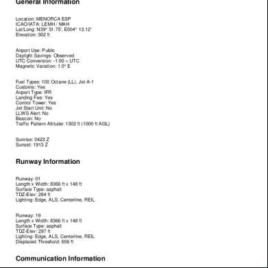
Lemh 60521z
January 2022 0More Documents from "albert" 6k10j

Intelligentsia Cupping Form 705841
February 2022 0
Dietmar Wolf - Intermediate Powerlifter 35r2z
November 2019 165
Mercedes Om 906 Indonesian x296b
December 2020 0
Autocad Lecture Notes 3y4442
November 2019 139
Lemh 60521z
January 2022 0